The Two-Span Bridge of Hak
Location
The bridge is situated south of the village of Hak (Minkend) in the Kashatagh (Lachin) Region of the Republic of Artsakh. The village lies on the left bank of the Aghavno River at an elevation of 1,720–1,800 meters above sea level. Among the village's monuments is a two-span bridge (Fig. 1). Azerbaijan currently occupies the area.
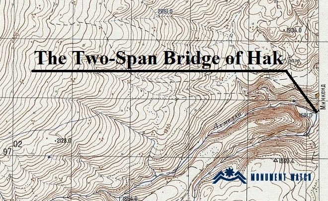
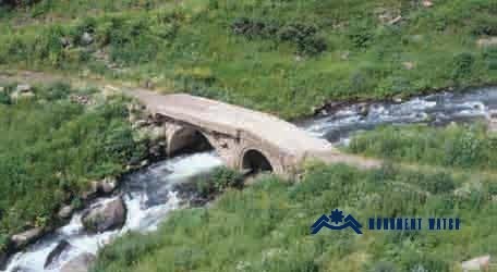
Fig. 1. The Two-Span Bridge of Hak. Photo by S. Karapetyan (Karapetyan 2009, 138).
Historical Overview
The village is first mentioned by the 13th-century historian Stepanos Orbelian as one of the settlements of the district of Aghahejk—in the north-eastern part of historical Syunik and bordering historical Artsakh—that paid taxes to the Monastery of Tatev (Hakobyan 1960, 209), in the amount of 15 units (Orbelian 1910, 516). The folk etymology of the toponym Minkend (Turk., lit. "thousand village") is linked to a legend according to which it was the thousandth settlement destroyed during Timur's campaign (Ghanalanyan 1969, 172).
Hak remained Armenian-inhabited until the early 18th century, after which it was depopulated of Armenians and settled by Kurds. Only in 1841 did an Armenian population re-establish itself in the village, migrants from Khndzoresk, who lived in a separate quarter. The Armenian inhabitants suffered heavily during the Armenian–Tatar clashes of 1905, and in 1918, the village was finally emptied of Armenians. In the Soviet period, the population consisted of Turkified Kurds (Karapetyan 1999, 129–130).
Architectural–Compositional Examination
The bridge south of Hak is a two-span bridge. According to researchers, it was built in the 1900s (Karapetyan 2009, 138). It bears numerous traces of later repairs and long served a practical transport function. Of its two arches, the right-hand arch is narrower than the left-hand (broader) arch. The arches also differ in construction technique. The right arch's ring/edge courses are built in two courses of finely dressed local basalt. In composition, it matches the arch ring of the nearby Aghbatkhert Bridge, dated (per the monument passport) to the 18th century. The left segment of the two-span bridge likewise has double-edge courses, but here the stones are more roughly hewn. Lime mortar was also employed in the construction.
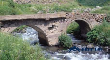
Fig. 2. The Two-Span Bridge. Photo by S. Karapetyan (Karapetyan 2009, 138).
The Condition Before, During, and After the War
During both the Artsakh wars and the 44-day war, the monument did not sustain damage. Following the occupation of Artsakh and the forcible displacement of the population, no information about the monument has been available.
Bibliographic Examination
There are no scholarly studies explicitly devoted to the monument. S. Karapetyan makes a brief mention of this bridge in his Bridges of Artsakh (Karapetyan 2009, 138).
Bibliography
- Karapetyan 1999 - Karapetyan, S. Monuments of Armenian Culture in the Districts Annexed to Soviet Azerbaijan. Yerevan.
- Karapetyan 2009 - Karapetyan, S. Bridges of Artsakh, Book XII. Yerevan, 144 pp.
- Hakobyan 1960 - Hakobyan, T. Outlines of the Historical Geography of Armenia. Yerevan.
- Ghanalanyan 1969 - Ghanalanyan, A. Armenian Traditions. Yerevan.
- Orbelian 1910 - Stepanos Orbelian, Patmut‘iwn Nahangin Sisakan (History of the Province of Sisakan). Tiflis.
The Two-Span Bridge of Hak
Artsakh