This time, Azerbaijani propaganda is engaging in discourse regarding Tigranakert
It's noteworthy that despite their ignorance, the Azerbaijani side has begun to incorporate excavation materials, drawings, and sketches from Armenian archaeologists into their discourse (https://www.youtube.com/watch?v=JasrYqTwhOA). Naturally, accusations persist, alleging illegal excavation, concealment of findings, and the relocation of khachkars from elsewhere to Tigranakert. Nevertheless, there's a discernible advancement: they attempt to discredit us by showcasing our endeavors, albeit in a half-hearted, patronizing manner, occasionally even resorting to mockery.
Before speaking about Tigranakert, please ensure you have a basic understanding of it. We are sharing an article and pictures by Hamlet Petrosyan, the expedition leader, as an aid to the Azeri agitprop.
We will soon be launching a trilingual website dedicated to Tigranakert. The website will present all the facts and details about Tigranakert in about 40 different sections. The website is being launched as a “recognition and tribute” to agitprop. Can you guys get serious, at least a little?
For those seeking publications that cater to a more serious audience, we recommend the following options:
- https://www.academia.edu/103276739/Hamlet_Petrosyan_Tigranakert_in_Artsakh_Caucasian_Albania_An_International_Handbook_Edited_by_Jost_Gippert_and_Jasmine_Dum_Tragut_The_Gruyter_Berlin_Boston_2023_pp_433_471
- https://www.academia.edu/49514867/Politics_Ideology_and_Landscape_Early_Christian_Tigranakert_in_Artsakh
- https://www.academia.edu/45639493/Ethnocide_in_Artsakh_The_Mechanisms_of_Azerbaijan_s_Usurpation_of_Indigenous_Armenian_Cultural_Heritage։
"Monitoring of cultural heritage of Artsakh" team. (MONUMENT WATCH)
TIGRANAKERT OF ARTSAKH
Tigranakert of Artsakh, which came under Azerbaijani control following the 44-day war, is situated in the Askeran region of the Republic of Artsakh (Nagorno-Karabakh), nestled within the inner valley of the Khachenaget, the second-largest river in the highlands. The city, along with its ancient fortified district and urban areas dating back to the first century BC to the first centuries AD, extends across the southwestern inner slope of Mount Vankasar and the adjacent hollow near the Royal Springs, spanning over 70 hectares of space (Fig. 1).
The immediate environment of the city encompasses the monuments of Vankasar and Tsitsar, the ancient eastern necropolis, the canal, and the Christian rock-cut worship complex, spanning an area of approximately four square kilometers. Tigranakert served as a significant administrative and religious (Christian) center during the early Middle Ages, from the 4th to the 9th centuries.
Fig. 1 The central part of the city.
The city was established by the Armenian king Tigranes II the Great (95-55 BC) in the late 90s BC. Its remnants were uncovered in 2005, and from 2006 to 2020, extensive archaeological excavations were conducted within its precincts by the Artsakh expedition of the Institute of Archaeology and Ethnography of the National Academy of Sciences of the Republic of Armenia. Notably, Tigranakert of Artsakh stands as the sole settlement among the numerous ones bearing Tigranes' name whose precise location has been identified and subjected to archaeological scrutiny. In 2010, based on the wealth of archaeological findings unearthed, the city's archaeological museum was established.
As a result of archaeological research, evidence suggests the existence of a substantial settlement characterized by sophisticated Hellenistic fortifications and urban planning techniques. Established in the first century BC, it endured until the late 13th century (Fig. 2). The city comprised a sprawling ancient Fortified District, strategically positioned across the mountainside with artificial ramparts and formidable walls. Additionally, it encompassed ancient urban districts scattered across the plains, cemeteries, and expansive agricultural outskirts. Constructed entirely from indigenous milky limestone, the city maintained its significance as a vital administrative and religious Christian center during the early Middle Ages (5th-7th centuries).
Fig. 2 The marking of the city's excavated areas during its excavation. Archaeological studies are conducted on Tigranakert and the neighboring complexes and monuments. 1. First Antique Quarter; 2. Early Christian Quarter; 3. Fortified Quarter; 4. Early Christian Cemetery; 5. Eastern Antique Cemetery 6. Rock-Cut Mower, 7. Royal Springs, 8. Mosque and pool from the eighteenth century, 9. The district of Antiquity; 10. The sanctuaries of Tsitsar.
The fortified quarter (refer to figures 3-5) is situated on a triangular promontory. At its pinnacle stands a rectangular tower, serving as the starting point for the southern and northern walls, which form the sides of the triangle. The foundations of both the outer and inner rows of the walls were hewn into the rock, fashioned as bands with recesses for the ashlar blocks.The recesses were filled with lime mortar, into which the ashlar blocks were embedded and secured. Besides reinforcing the blocks of the first row and filling the gaps between them, the mortar was also utilized to seal the space between the foundation and the rock, preventing rainwater from seeping underneath. The fortification was meticulously adapted to the vertical and horizontal contours of the terrain, skillfully incorporating various groove ribbons, steps, and platforms. At its base, the wall doesn't rest on a single solid mass but on three distinct "legs" – the outer and inner rows and the mass between them – which served an anti-seismic function by dispersing tremors into components near the base.
Fig. 4 The layout of the fortified district.
Fig. 3 A fragment of the north-fenced wall.
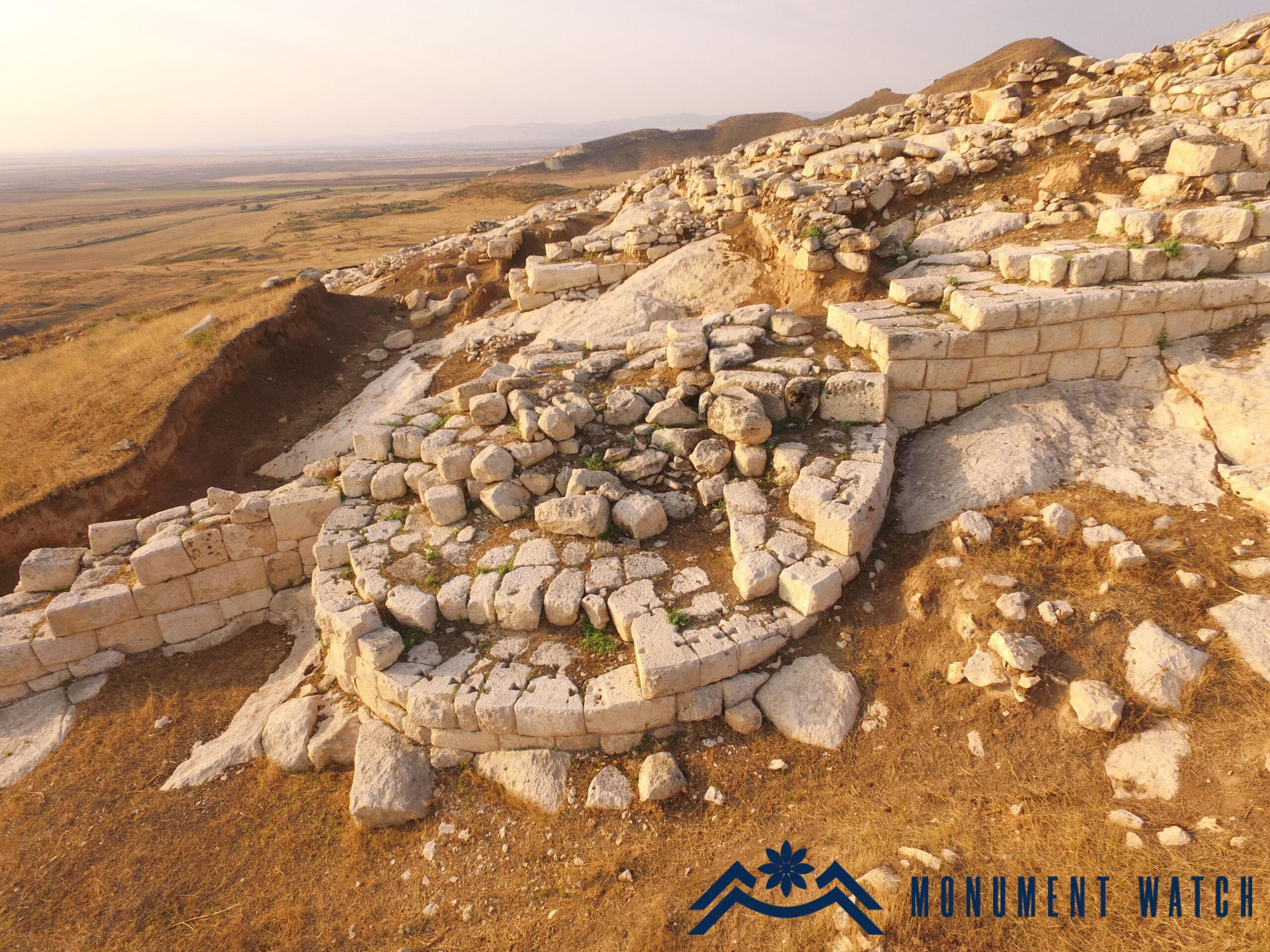
Fig. 5 The second round tower of the northern wall.
The ashlars forming the outer and inner rows of the wall exhibit meticulously aligned contact surfaces, featuring a rustic (cushion) treatment on their outer faces and expertly crafted fascias (slanted cuts on the outer edges of the squares). While larger squares are stacked directly on top of one another, smaller ashlars are additionally reinforced with swallow-tail joints. Although this construction technique was commonly utilized in regions like Asia Minor, Mesopotamia, and the Ararat Valley, its discovery in Artsakh represents the first known instance of its application in the region.
In the construction of the Tigranakert fortress, a triangular model was employed, featuring consecutive rectangular and round towers interconnected by zigzag walls. The varying lengths and orientations of these walls served as technical adaptations to maximize the natural defensive capabilities of the site.
The defensive architecture of Tigranakert exhibits striking similarities with classical Near Eastern structures found in cities such as Miletus, Ephesus, Pergamon, Priene, Magnesia on the Meander, and Dura-Europos. Additionally, parallels can be drawn with certain monuments in the Transcaucasian region, including Artashat and Armaztsikhe-Bagineti.
Tigranakert was constructed with the comprehensive application of advanced architectural principles and construction techniques of its era. This distinction renders Tigranakert a benchmark monument of the first centuries AD, as it is remarkably well-preserved compared to the contemporaneous complexes of the listed monuments.
The excavations at Tigranakert have unearthed a diverse array of artifacts, including colorful pottery, metal ware, and jewelry dating from the first century BC to the first century AD. Notably, discoveries such as antique seal gammas and Sasanian seals underscore the city's significant commercial and administrative significance.
Ancient urban districts
The town districts situated in the plain at the base of the citadel play a crucial role in elucidating the urban layout of Tigranakert. Among the four archaeologically confirmed ancient quarters, excavations have revealed a portion of the First Antique Quarter, while exploratory excavations have been conducted in the Second Antique Quarter. The first district was contemporaneously constructed with the citadel and endured until the 7th century AD.
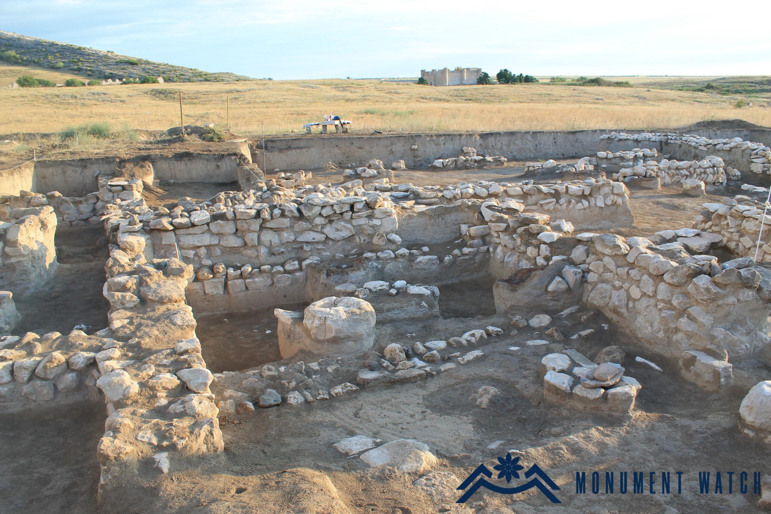
Fig. 6 The first ancient district.
The urban planning of Tigranakert followed a zoning principle akin to Hippodamian construction, characterized by straight street sections, rectilinear walls, and predominantly rectangular plots. At the heart of the excavated area lies a north-south straight wall, extending up to 25.5 meters in length. On either side of this central axis, residential and economic complexes comprised of approximately square rooms were situated. In the subsequent two construction phases (3rd-7th centuries AD), reconstructions largely replicated the layout solutions of existing buildings. The rooms featured clay floors, occasionally with remnants of plaster, and primitive fixtures for the wooden columns supporting the roof. Some rooms preserved hearth-burners positioned 0.30 meters above the floor, while late antique rooms saw the addition of ovens. In certain rooms, limestone alumnus are embedded within the tiled areas of the floors. Discoveries of alumnus handles and mills within this setting, alongside remnants of pots fixed into the floor, suggest that each household independently addressed the issue of bread production. Moreover, the presence of dozens of cone-shaped, pyramidal, and donut-shaped parcels crafted from raw weaver's clay potentially indicates the domestic nature of this craft.
The antique pottery unearthed at Tigranakert is remarkable, showcasing thousands of fragments ranging from black-polished to red-colored pottery. Additionally, dozens of complete vessels have been discovered, spanning from large pots and churns to delicate jugs, flasks, various bowls, and fish bowls.
The black-glazed vessels adorned with beads and the exquisite examples of colorful pottery bearing Atropatene origins serve as unique evidence of Tigranakert's role in establishing cultural standards along the right bank of the Kur River. Additionally, noteworthy are the imported pottery examples, which exhibit parallels extending to Tigris Seleucia and Dura Europos.
The ancient eastern burial ground (Figs 7 and 8) is situated on the plain approximately one and a half kilometers northeast of the city center. Excavations have uncovered and examined one stone burial and six jar burials at this site. Additionally, another pot burial was unearthed during excavations of the northern wall of the castle, positioned inside the castle near the wall.
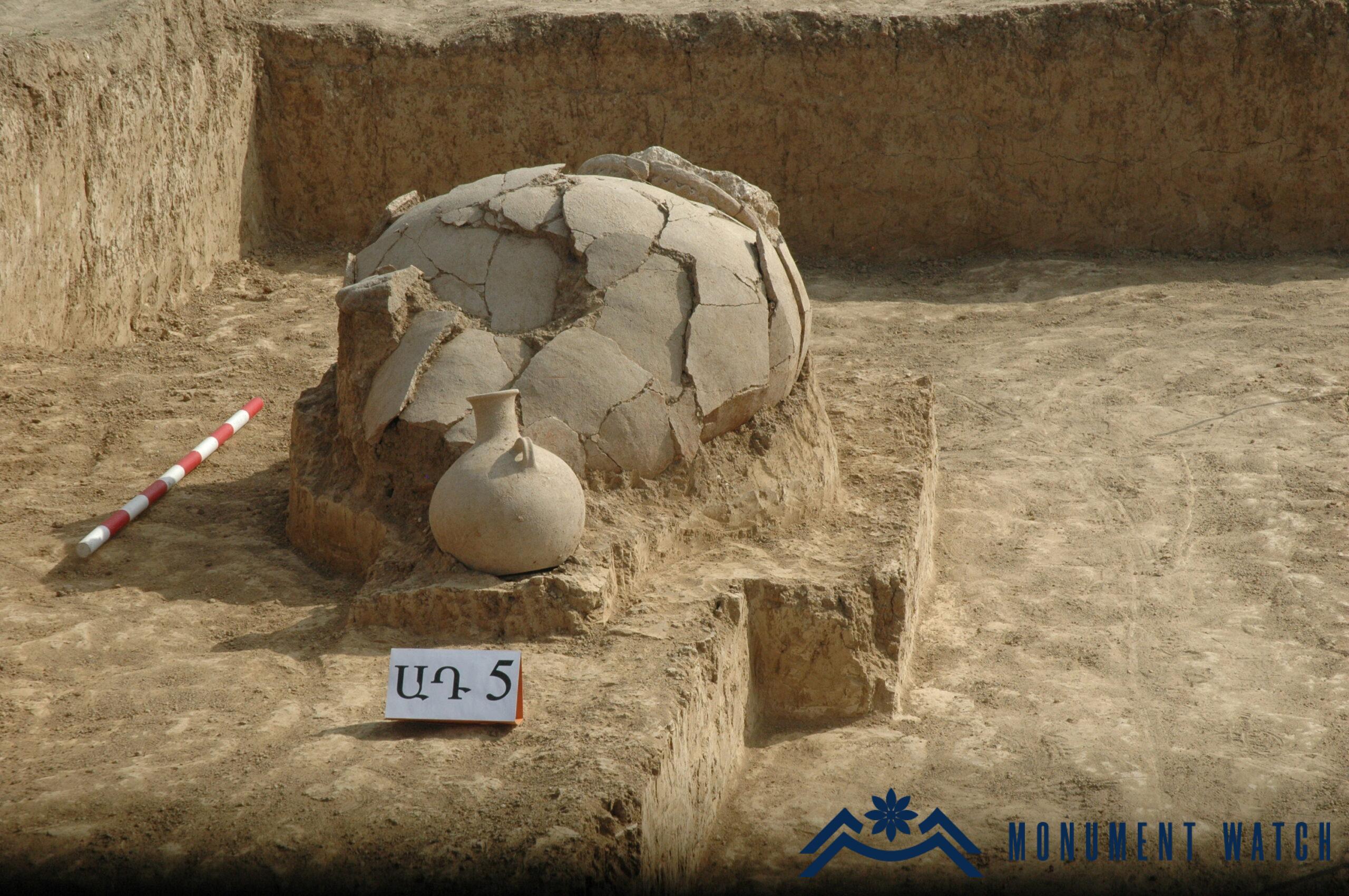
Fig. 7 The ancient eastern burial site, jar burial, first century BC - first century AD.

Fig. 8 One of the pottery burial vessels.
The burials exhibit a lack of uniform orientation, with pitchers placed horizontally oriented from northwest to southeast or from northeast to southwest, displaying various deviations. Among the findings from these burials are well-preserved Parthian silver drachmas, examples of weaponry and household items, and a diverse array of jewelry including gold-foil beads, gem-studded rings, gold pendants, earrings, and hundreds of beads. Additionally, perfect examples of jars and water vessels were discovered within the burial sites. The vibrant belt adorning the shoulder of an amphora-type burial pitcher portrays a hunting scene, featuring deer, mounted hunters armed with spears and bows, and dogs amidst towering deciduous trees. Pottery burials were a widespread form of interment both in the BC and AD periods across a large region during the first centuries. Based on available research, this burial rite appears to be more prevalent in Transcaucasia. It is evident that this pre-Christian form of burial predominated in Artsakh and Utik.
The early Christian square (Fig. 9). During the early Christian period, Tigranakert flourished as a prominent military, administrative, and religious hub situated in close proximity to Barda. Evidence of the medieval city is evident in a 7-hectare expanse extending from the late medieval castle towards the southeast, elevating 4-6 meters above the surrounding terrain. In the heart of this area, prior to excavation efforts, large segments of stone walls were discernible, flanking the edges of a broad pit. Between 2006 and 2009, extensive excavations unearthed the remains of a substantial early Christian temple known as the Great Church (Fig. 10), situated approximately 3.5 meters beneath the surface. It follows the architectural style of single-nave basilicas that were prevalent in Armenia and the Caucasus during the 4th and 6th centuries. Originally, it comprised a single-nave hall with an external pentagonal apse. Subsequently, the pentagonal structure was integrated into the rectangular volume, and a southern sacristy was added, accessible from the exterior. Constructed from large sacred blocks and lime mortar, the church sits atop a three-level earthen rampart. It features one western porch and two porches on the southern and northern sides, adorned with a dentil cornice and a wooden and tiled roof. The porches are supported by pairs of intricately carved columns topped with elaborately decorated capitals. Excavations uncovered numerous examples of dentil cornices, carved columns, hundreds of tile fragments, two crucifixes, a cross with luminaries, and a cross in a garden setting (Fig. 11).
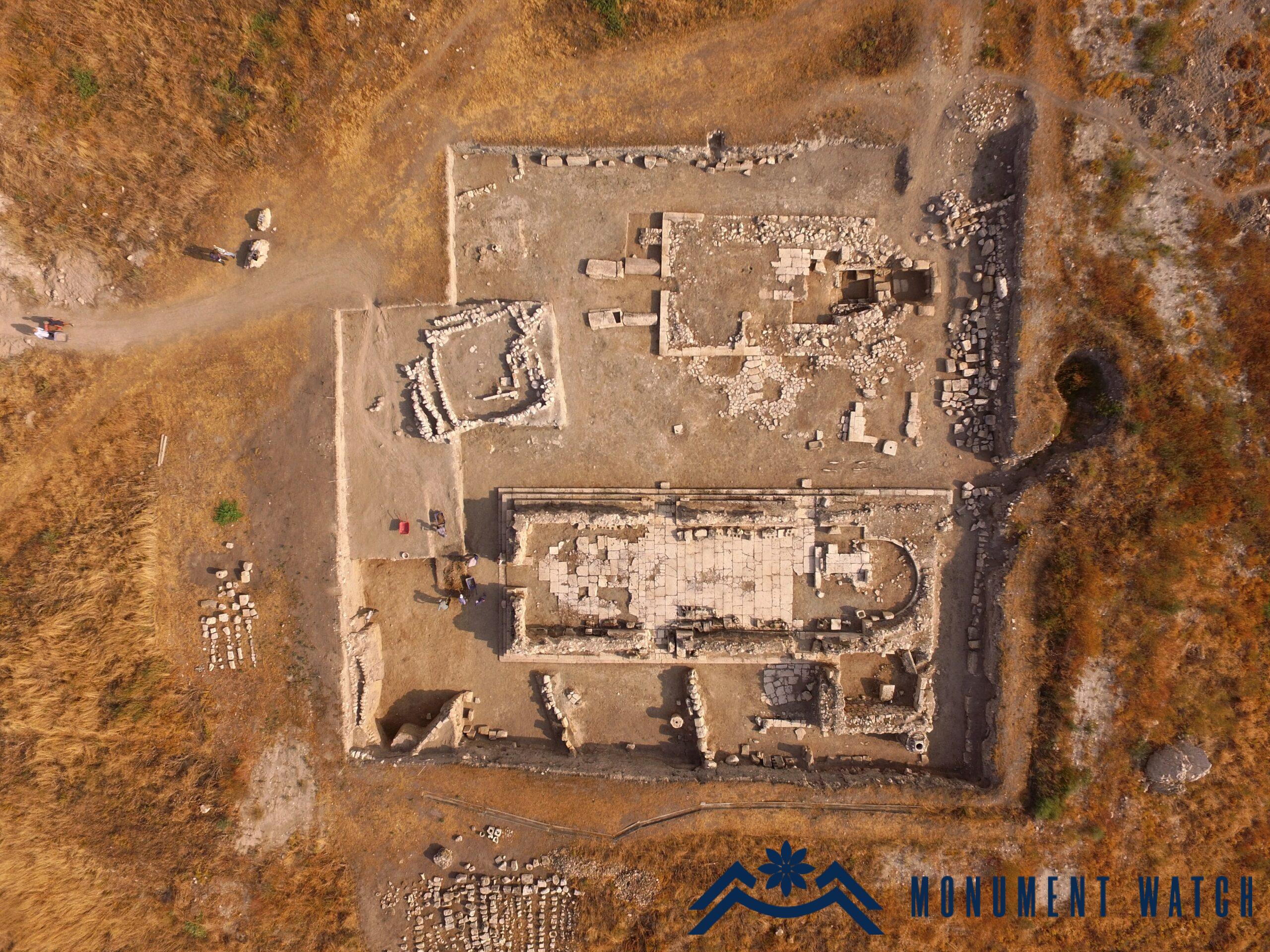
Fig. 9 The early Christian square.
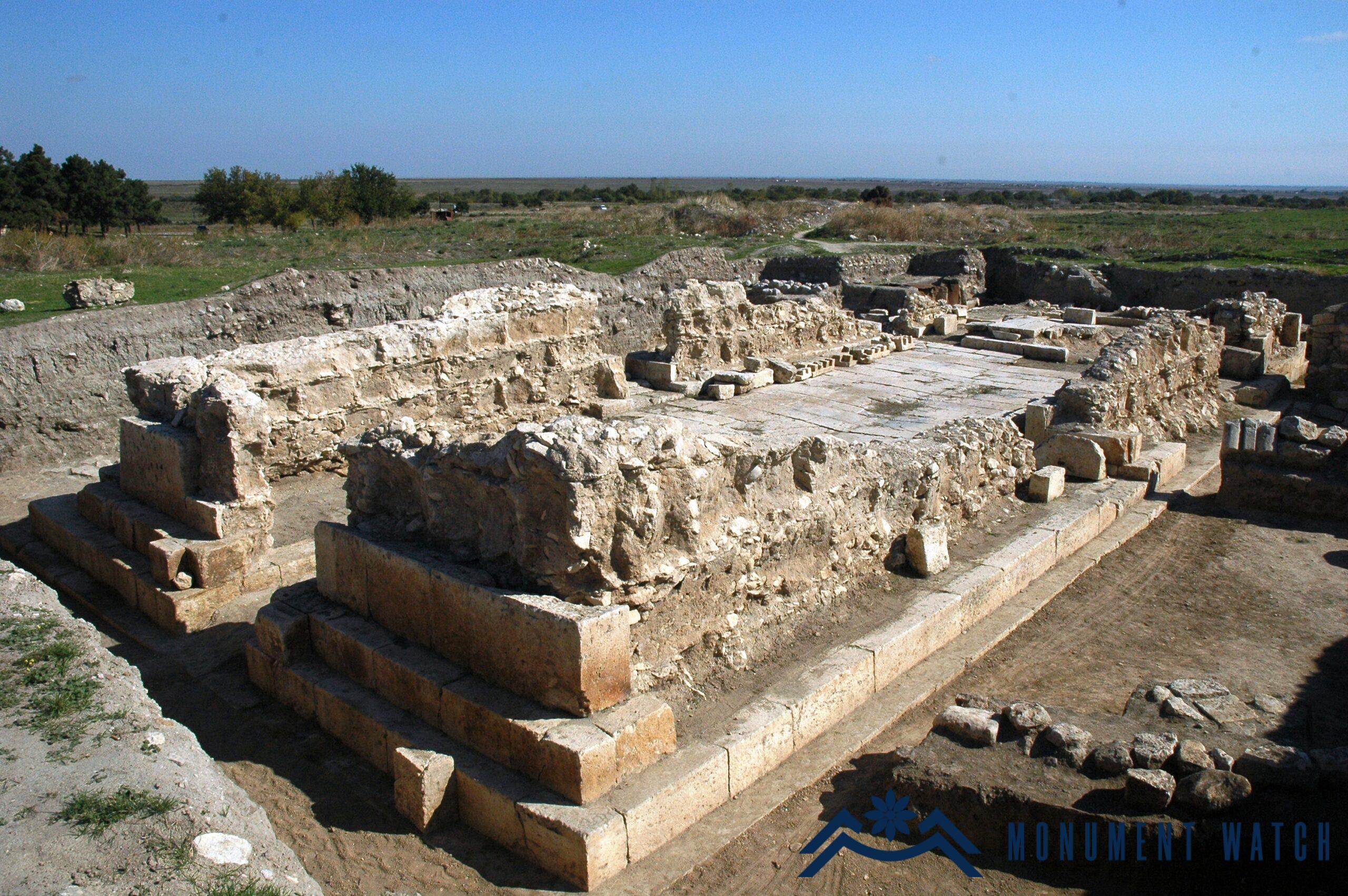
Fig. 10 The Great Basilica Church, 5th-6th centuries.
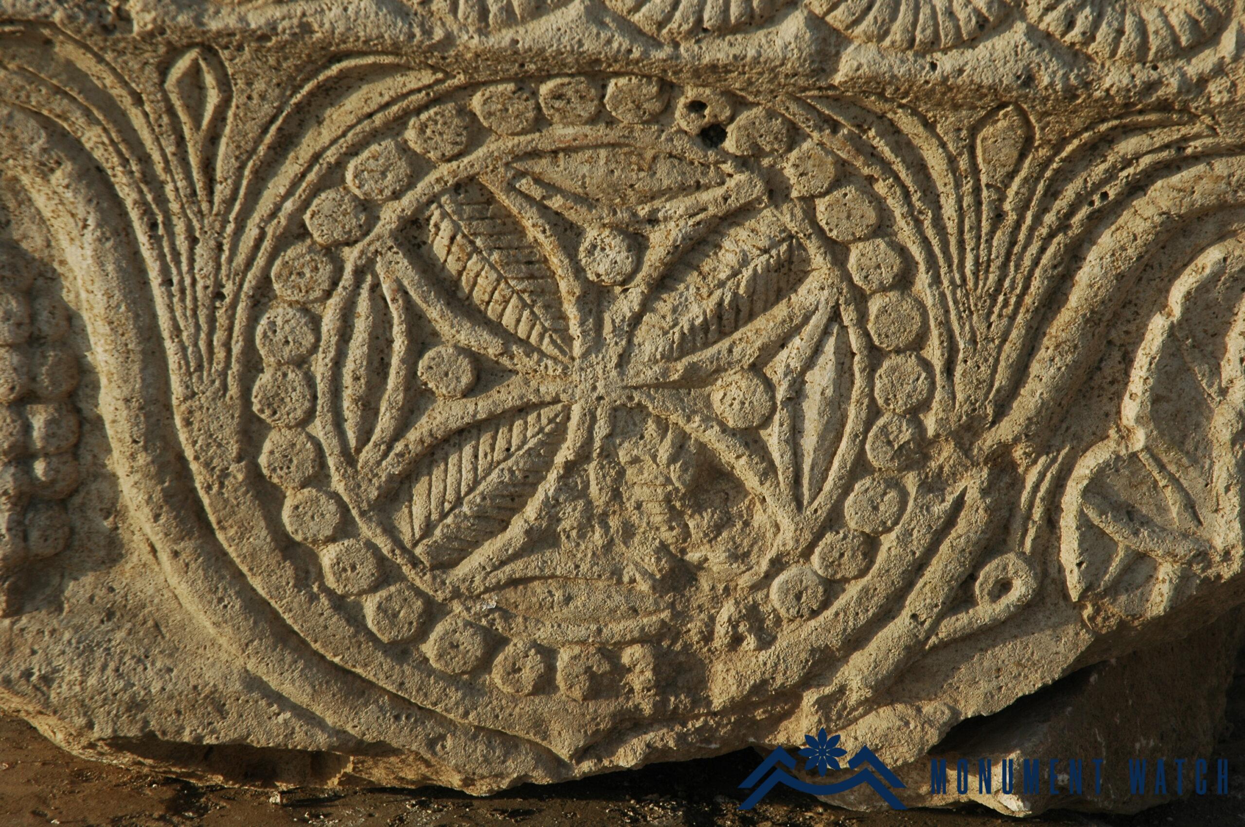
Fig. 11 The capitals with a cruciform composition, a large church, 5th-6th centuries AD.
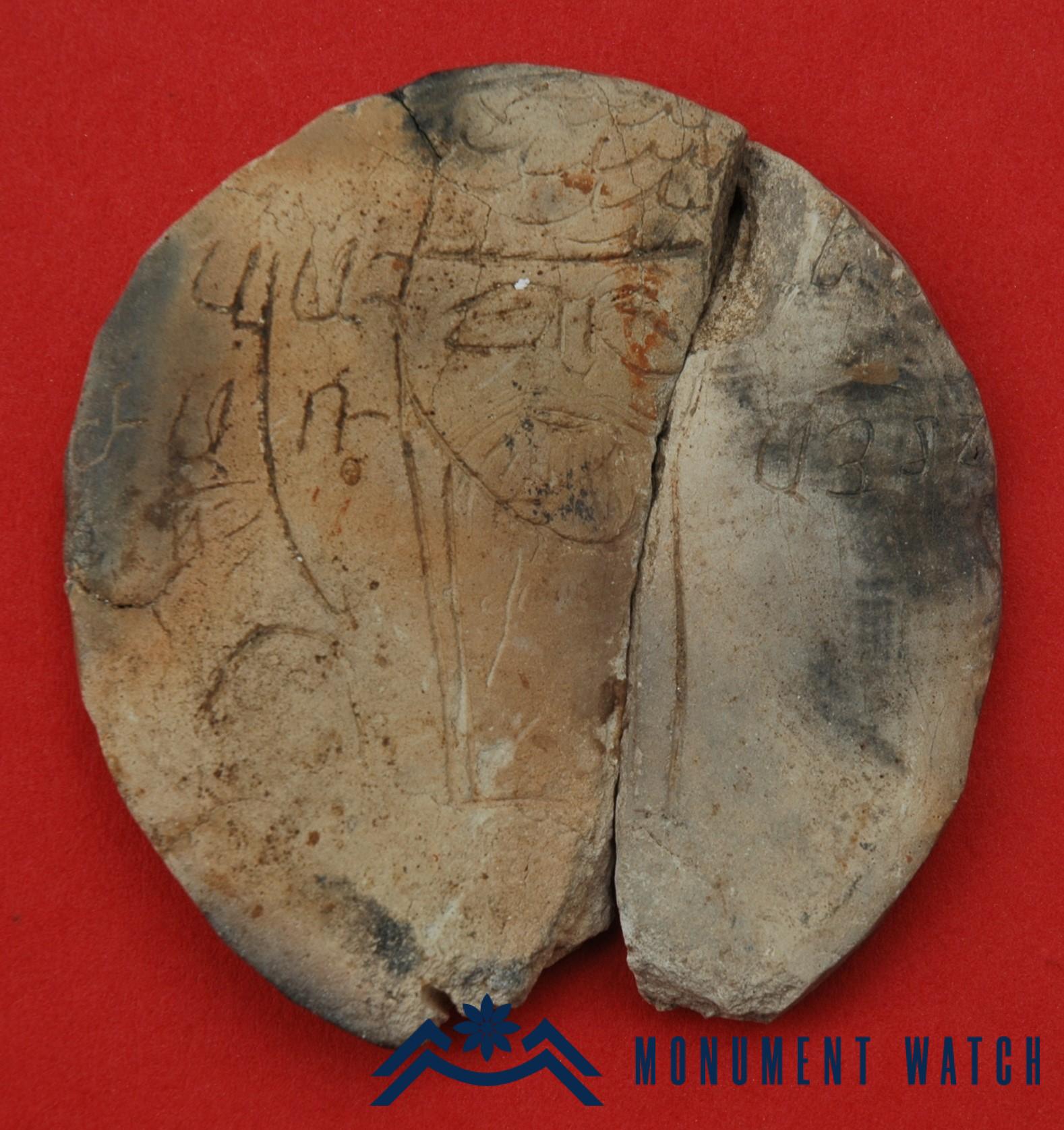
Fig. 12 From the capitals of the Great Church, 5th-6th centuries.
A disk-shaped clay object bearing an Armenian inscription from the 5th-6th centuries is noteworthy (Fig 12). The church met its demise through destruction and fire at the close of the 9th century, after which residential complexes were erected atop its ruins.
Excavations in the northern courtyard unveiled a spacious paved area containing remnants of an early Christian crucifix, a basilica (small church) featuring a prominently projecting apse, an adjoining graveyard to the west, and a reliquary beneath the eastern apse.
The existence of a square featuring such a substantial and elaborate Early Christian construction serves as a significant piece of evidence supporting the notion that Tigranakert retained its status as a prominent settlement during the early Middle Ages.
In the immediate vicinity of the city, significant landmarks include the Vankasar Church (7th century, Fig. 13), the canal featuring tunnel sections (Fig. 14), the early Christian rock carving complex (Fig. 15), and the sanctuaries of Tsitsar (Fig. 16), all of which have undergone thorough research and study.
During the 44-day war, Tigranakert became a target for enemy shelling, destroying the archaeological site (Fig. 17). In response, Artsakh authorities and our research team took immediate action to prevent the Tigranakert Archaeological Museum from suffering a similar fate. The museum collections were promptly evacuated and relocated to a secure location. It is essential to emphasize that the archaeological findings from the excavations at Tigranakert are the property of the people of Artsakh. The political non-recognition of Artsakh, along with occupation and forced displacement, cannot negate the inherent right of its indigenous people to their culture, including the management of their material cultural heritage. The Azerbaijani strategy of attempting to deprive the people of Artsakh of their cultural heritage is viewed as a continuation of the genocidal targeting of Armenian cultural heritage. The ongoing genocide, which we have tragically witnessed for decades, reached its peak with the destruction of thousands of khachkars in Jugha between 2005 and 2006. This cultural genocide has only intensified following the 44-day war and has become a grim reality in Artsakh since the ethnic cleansing in September 2023. Such atrocities cannot be justified by false political statements or fabricated accusations. No amount of aggression, military dominance, ethnic cleansing, or threats against Armenians can legitimize the deprivation of the people of Artsakh of their fundamental right to preserve their identity through their cultural heritage.
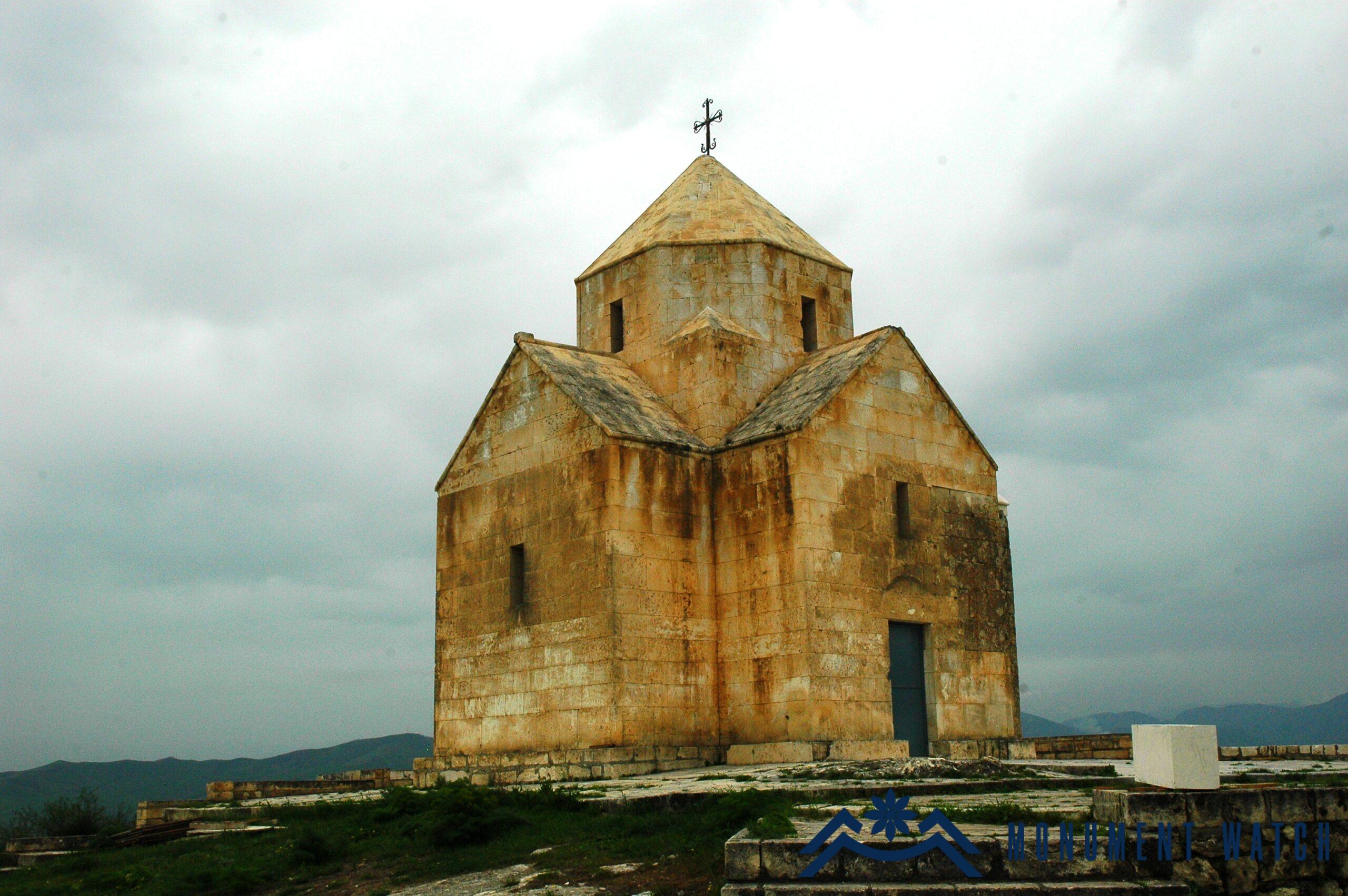
Fig. 13 The church of Vankasar, 7th century.
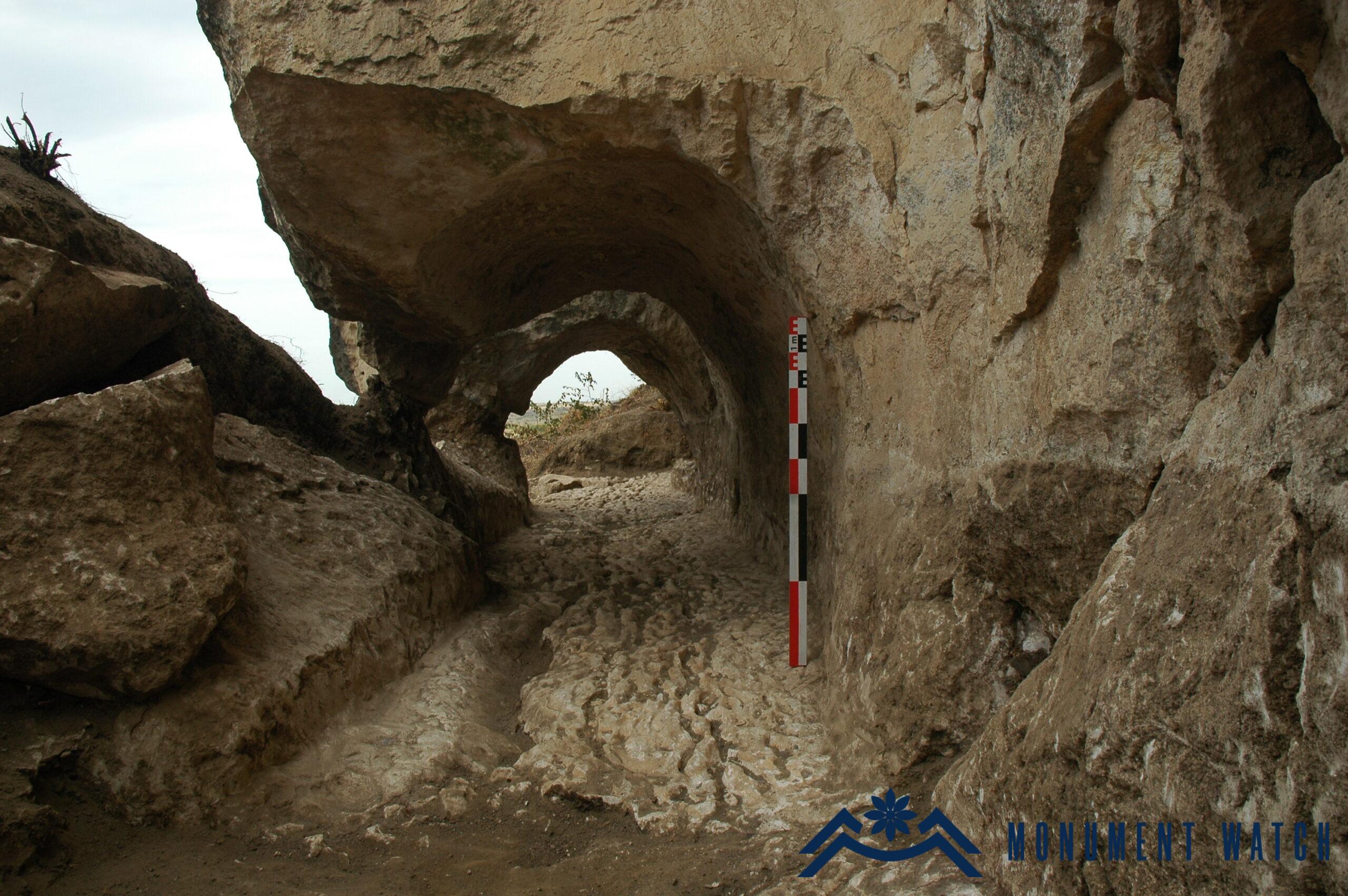
Fig. 14 One of the canal tunnels.
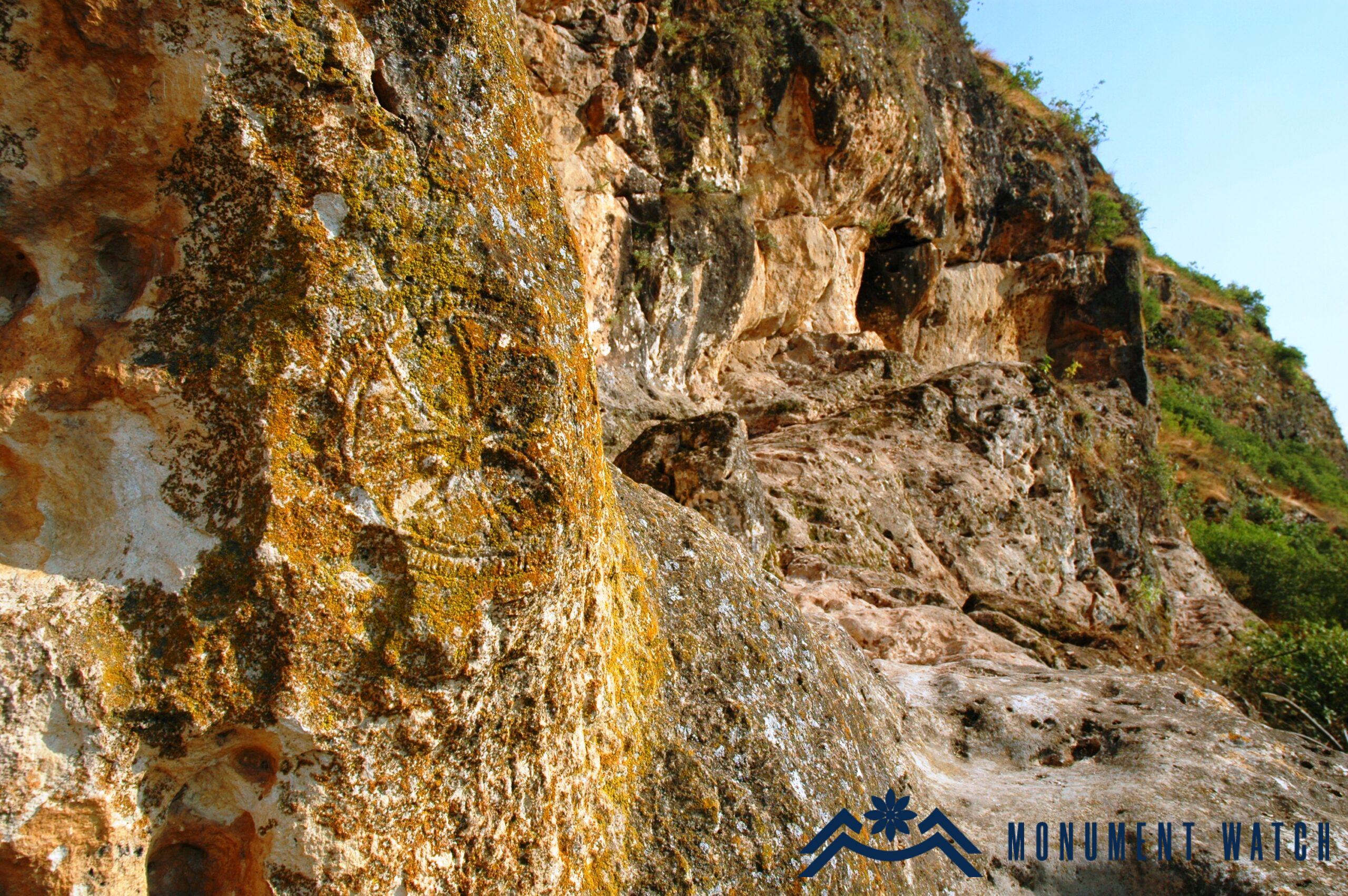
Fig. 15 The early Christian rock-hewn complex, a section, 7th-9th centuries.
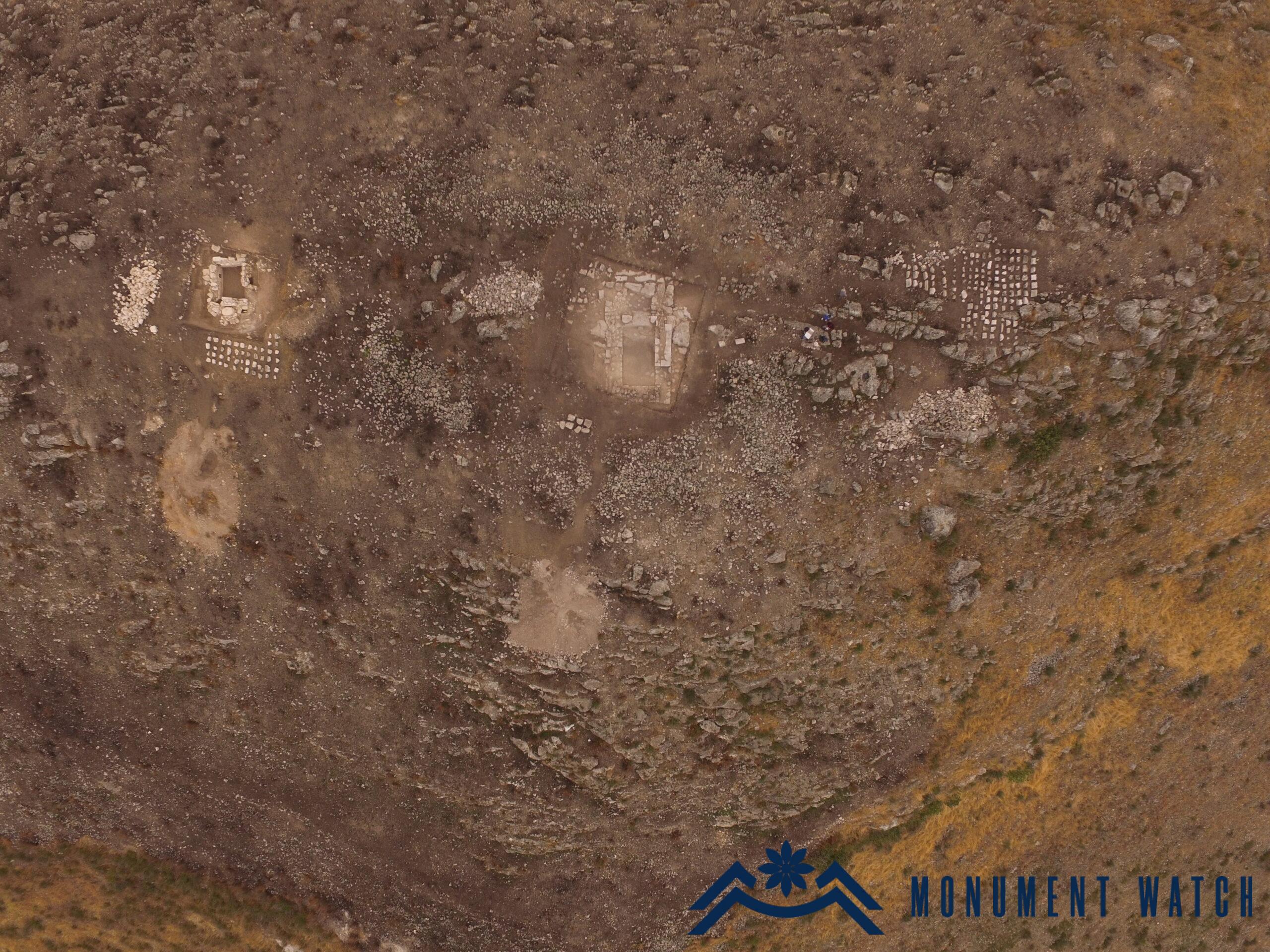
Fig. 16 The sanctuaries of Tsitsar, 5th-13th centuries.
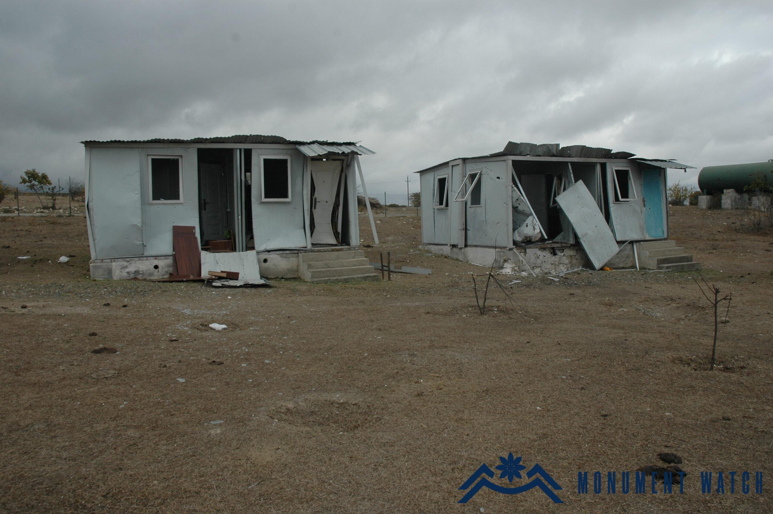
Fig. 17 The archaeological site of Tigranakert after the Azerbaijani shelling, October 2020.
After the 44-day war, Azerbaijan has been utilizing the Tigranakert monument as a tool for its propaganda. This monument holds immense cultural and civilizational significance in the Caucasus region. Unfortunately, it is being devalued by Azerbaijani dignitaries and archaeologists. For instance, the early Christian church located in the city is being misrepresented as a bathhouse. Sarcophags are erroneously referred to as water cisterns, and the park of the Royal Springs has been transformed into a place for eating (see details https://monumentwatch.org/en/2023/11/09/azerbaijani-led-excavations-in-tigranakert-an-overview/; https://monumentwatch.org/en/alerts/again-and-again-tigranakert-and-the-tigranakert-expedition-under-the-blow-of-azerbaijani-propaganda/; https://monumentwatch.org/en/alerts/tigranakert-of-artsakh-does-exist-regardless-of-what-azerbaijani-propaganda-says-about-it/).
Hamlet Petrosyan,