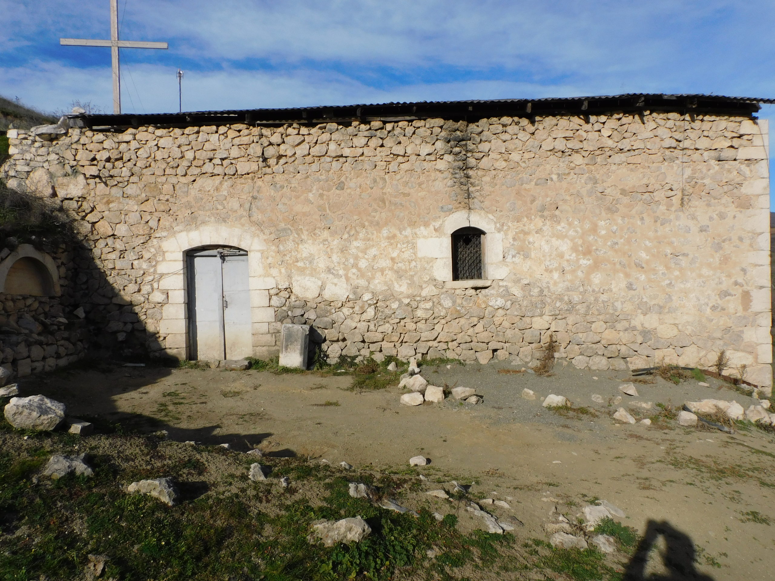
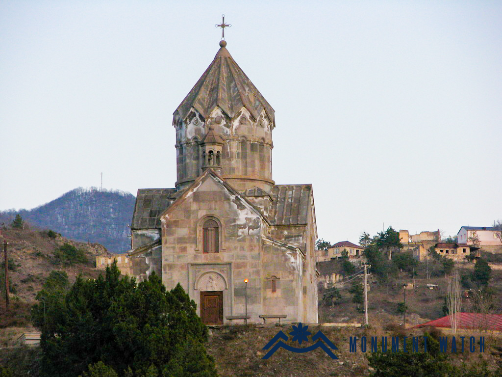
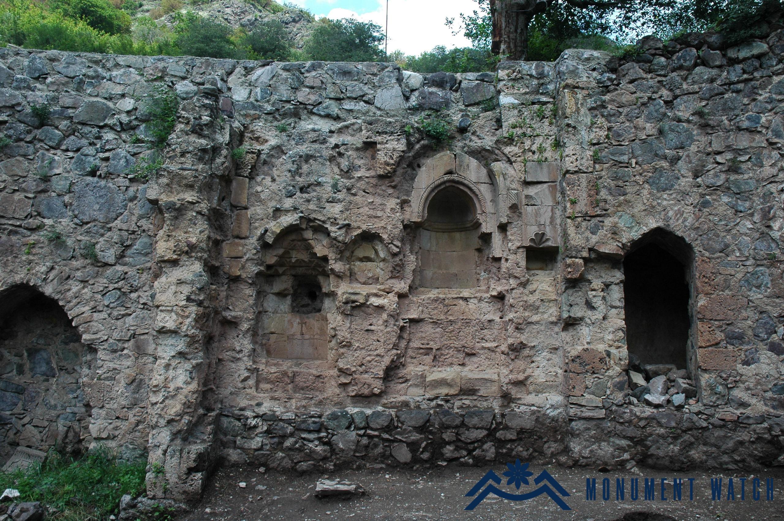
Location The church is located in Karmrakutch village, at an elevated point (Fig. 1). Historical overview Although Makar Barkhutaryants brings references on the church, the year of construction is missing. The dates of construction (1844) and renovation (1964) are engraved on the arch lock stone of the entrance facade (Fig. 2). Architectural-compositional description The church is a single-nave hall with a semi-cylindrical vault, an eastern semicircular altar and adjacent vestries. It is built of rough limestone and lime mortar. The cornerstones, windows and door sills are hewn. The dimensions of the monument are 12.8 m long and 7.4 m wide (Barkhutaryants 1895, 70). The only entrance is from the southern side. The hall is illuminated through narrow windows from the eastern altar and the western facade and the opening of the belfry crowned with a six-column rotunda in the center of the vault (Fig. 3). The church was restored in the 2000s and covered with tiles.

Location The church is located in Khandzadzor village of Hadrut region of the Artsakh Republic. The village is situated on the southeastern slope of Dizapayt, in a bare and unattractive area (Fig. 1), from where it got its name. The village is also called Tsarishen, which is associated with a large elm growing in the center of the village (Mkrtchyan 1985, 128). Researcher Shahen Mkrtchyan gives a very brief description of the village and the church in his book on the monuments of Nagorno Karabakh, published in Armenian in 1985. The author refers to the church in more detail in the book dedicated to the monuments of Nagorno Karabakh, already published in Russian in 1988 (Мкртчян 1988, 104). The church is located in the southeastern, elevated district of the village, next to the monument dedicated to the Patriotic War. Historical overview There is no historical information about the church. According to the certificate of St. Astvatsatsin Church of Khandzadzor made by the Monument Protection Department of the MESCS of the Artsakh Republic, the church was built in the 19th century on the site of a former church. Architectural-compositional description The church plan presents a rectangular, single-nave vaulted hall with an eastern semicircular altar and adjacent vestries (Fig. 2), at that the bema is only one step above the prayer hall (Fig. 7). The cylindrical vault rests on an arcade composed of wall-adjacent columns. The dimensions of the church are 14 X 6 X 7 meters. The only entrance is from the south (Fig. 3). There are two large cross reliefs on the upper stone of the lintel, which was reused twice and adapted for the lintel. On the right and left sides of the entrance there are khachkars typical of the 17th century (Fig. 4), whose right side has an inscription. The church is built of local semi-finished limestone (Figs. 5, 6). The condition before and after the war The church was not damaged during the Artsakh wars, it served as a warehouse during the Soviet years. It needed to undergo repairs. It is located in Hadrut region presently occupied by Azerbaijan and there is no information about its future.
Location The church is located about 600 meters east of Berdahonj fortress, on an elevated place in a forested area, on the edge of the old road leading to Shekher. Historical overview Makar Barkhutaryants mentions this church, but does not provide any information about the construction period (Barkhutaryants 1895, 90).

Location Berkni village, which is part of Kovsakan (Zangelan) settlement, is located in Kashatagh region of the Artsakh Republic, 110 km south of Berdzor, 1 km away from the RA border. There is a single-nave basilica-type church 0.9 km away from the village on the left side of the Tsav River (Figs. 1, 2). Historical overview There exist no bibliographic data and records about the church. Based on architectural-compositional solutions and the stylistics of the existing cross images, the church dates back to the 17th century. Architectural-compositional examination The church of Berkni is built of local rough stone and lime mortar. It used to be plastered inwardly. The structure is a single-nave, vaulted basilica with an accentuated arched altar and a pair of rectangular vestries on the eastern side, with the external dimensions of 14.50×9.10 meters (Karapetyan 2001, 196, Fig. 3). The semi-cylindrical vault rests on double-span arches adjacent to the walls and is fixed by an arch rising on the pilasters attached to the northern and southern walls (Fig. 4). The only entrance is from the southern side. The church has five windows, three of which open on the eastern wall (one on the high altar and two on the segments of vestries), one on the southern wall and one on the western wall. There are window-niches on the right and left sides of the altar. The baptismal font is located in the niche of the northern wall. Khachkars are embedded into the walls (Fig. 5). The cemetery of the settlement is located near the building. There are simple tombstones here, some of which bear cross reliefs. Remains of a small structure can be observed in the centre of the cemetery (Rkoyan 2015). One of the khachkars is dated to the 11th century (Fig. 6). The condition before, during and after the war The church of Berkni was not subjected to changes before or after the war. Bibliographic examination Researcher S. Karapetyan in his book “Armenian cultural monuments in the region of Karabakh” describes the village and the church but does not mention the cemetery (Karapetyan 2001, 195).
Location The church is located in the center of Ukhtadzor village in Hadrut region of the Artsakh Republic, in a densely built-up residential area (Fig. 1). At real time it is under the Azerbaijani occupation. Historical overview The data about the church are scarce. According to the building inscription, it was built in 1692. Architectural-compositional description The monument is a single-nave vaulted hall with an eastern semicircular altar and attached vestries. It is built of rough limestone and lime mortar (Figs. 2, 3). The roof is covered with soil. It is completely stuck in the ground from the north (Fig. 4). The entrance is from the south, the curbs and the lintel are hewn, decorated with cross compositions (Fig. 5). The slabs with engraved crosses and fragments of khachkars are embedded into the walls (Fig. 6).

Location St. Astvatsatsin Church is located on the elevated northern edge of Sarinshen village of Hadrut region of Artsakh (Fig. 1). Historical overview Sarinshen village was originally called Shaghakh, which took its name from the famous Shagakh or Shakhkakh monastic complex near the village. The data on Sarinshen village and St. Astvatsatsin Church that have reached us date back to the 19th century: “Shaghakh village – Sari Shen: It is founded on the mountain of Karaglukh village: the residents migrated from Gharadagh, the land is royal, the local harvest is the same (sheep, emmer wheat, spring wheat, flax, millet), excellent air, climate and water, 115 years long life, the church of Saint Astvatsatsin built of stones and lime mortar, the priest comes from Tsamdzor. Households – 70, males – 275, females – 230” (Barkhutaryants 1895, 64). According to the inscription carved on the stone with a cross relief, embedded in the mid-part of the northern vestry and the altar of St. Astvatsatsin Church, it was built in 1867, but the khachkars and reliefs of the 16th-17th centuries on the walls prove that the church was built on the site of an older sanctuary. Architectural-compositional description St. Astvatsatsin Church is a vaulted building with a single-nave hall (dimensions: 15․1×6․3 meters, height: 7 meters). It is built of local rough and unfinished stones (Fig. 2). The cornerstones of windows, pilasters, arcature, niches and the bema are polished. The building inwardly ends in the east with a semicircular altar and adjacent rectangular vestries (Fig. 3). The vault rests on arrow-shaped arches rising from two pairs of pilasters. On the northern wall, in the niche, adjacent to the entrance of the vestry, there is a baptismal font, on both sides and above of which there are three small khachkars dated the 17th century (Fig. 4). In the southern wall opposite the font there is another niche, which served as an aumbry. The only entrance is from the south, which was closed during the Soviet years (Fig. 5). In the wall parallel to the closed entrance on the southern facade, two rectangular hewn stones with a pair of cross reliefs taken in similar frames are embedded. The illumination was provided through 6 windows opened from the east, south and west. During the Soviet era, the small western window was widened, and a new entrance was opened in the direction of the second window of the southern wall and the church served for another purpose (club-library). On the inner walls of the church, especially in the niches, cross reliefs and small donative khachkars are abundantly embedded. Particularly noteworthy are the reliefs on the bema, which represent the Just Judgment in the person of the Three Patriarchs and the enlightened coming of the Archangel Gabriel armed with a sword and the Cross (Fig. 6). The gable roof of the church was originally made of stone, which was covered with asbestos (slate) sheet during the Soviet years (Fig. 7). In 2016-2017, the slabs of the church were restored, some reinforcement works were carried out (Fig. 8).

Location St. Stepanos Church is located in Pletants village of Hadrut region of Artsakh, on the northern edge, on the south-facing slope. Historical overview The information on Pletants and St. Stepanos Church (Fig. 1) that have reached us dates back to the 19th century. Makar Barkhudaryants writes the following about the village and the church: “Pletants (Plitan): it is founded on the slope of a gorge of the same mountain (Arevasar): the people are indigenous, the land is royal, it has also a garden, pupae and an orchard, harmless air, climate and water: St. Stepanos Church, made of stone and lime mortar, the priest comes from Hatrut. 20 households: 90 males, 70 females” (Barkhutaryants 1895, 70). According to the building inscription engraved on the entrance lintel, the church was built in 1651. No other details are known about the construction of the church. Architectural-compositional description St. Stepanos Church is a vaulted building with a three-nave hall (dimensions: 17.2×8.7 meters). It is built of local rough-hewn stones (Fig. 2). The cornerstones of the entrance, windows, pillars, columns and arcature are polished (Fig. 3). Large-sized semi-finished limestone was used in the lower masonry of the walls. The walls are fixed with lime mortar. The hall is divided into naves by means of a pair of arches (Fig. 5). The baptismal font, crowned with an arrow-shaped arch, is placed in the niche adjacent to the entrance of the northern vestry. The building internally ends in the east with a semicircular altar and adjacent rectangular vestries (Fig. 4). There are niches of different sizes on the walls of the altar and vestries. The building is externally covered with a gable roof. The only entrance is opened from the centre of the southern front to the section deviated to the west. The entrance has a beautifully designed arched frame, the date of construction is engraved on the lintel (Fig. 6). The illumination was done through three small windows from the east, one from the west and two from the south. The window opening from the western facade externally has a cruciform frame (Fig. 7). The northern wall is externally merged with a slant slope and is covered with earth. A rectangular gravestone dated 1854 is located to the south of the church, to the east of the entrance, and two 17th century khachkars with simple cross images.
Location The Church of the Holy Resurrection (figs. 1, 2) is located in the Hadrut region, in the village of Hin Kochbek on the south-eastern slope of Mount Arevasar.

Location St. Astvatsatsin Church (Figs. 1, 2) is located in the center of Jraberd (Mulkudara) village of Hadrut region. Historical overview Mulkudara village (Fig. 3) is located 11-12 km southwest of the city of Hadrut. The village was evacuated of Armenians in 1991 as a result of Operation Ring. It was liberated in 1993 and renamed Jraberd. Only a few families returned to the village, who left the settlement in the following years. Jraberd has been under Azerbaijani occupation since October 2020. Architectural-compositional examination St. Astvatsatsin Church is a 19th century structure by its composition. It is a rectangular single-nave hall. The barrel vault rests on longitudinal and transverse arches rising from the columns attached to the walls (Fig. 4). The roof is gable, covered with soil. It is built of local white limestone. The only entrance opens from the south. A fragment of a gravestone of the 16th-17th centuries, decorated with cross-shaped compositions, has been preserved in the southern wall (Fig. 5). During the Soviet years, the church was used as a village club.

Location The church is located in Tzor village of Hadrut region of the Artsakh Republic (Mkrtchyan 1985, 132). The village is located at the southern foot of the historic Tzoraberd fortress (Barkhutaryants 1895, 43). Historical overview There is no historical data about the church. Its brief description is given by Makar Barkhudaryants: “…Amenaprkich Church, built on four pillars, marvelous and beautiful, its people-facing facade of the bema is delicately decorated, the length is 22 m, the width is 12 m 35 cm, externally on the front stone of the door: “In memory of the year of 400… a priest…” (Barkhutaryants 1895, 43). Architectural-compositional description St. Amenaprkich Church of Tzor is located in the central part of the village (Fig. 1). The building is a three-nave basilica with four pillars, a semicircular high altar and adjacent vestries (Fig. 2). It is built of local rough stone, has small windows. The only entrance to the church is from the south (Fig. 3). One line of illegible inscription has been preserved on the lintel (cf. CAE 1982, 186). Based on the compositional, architectural solutions of the church, it dates back to the 18th-19th centuries (Mkrtchyan 1985, 132). Internally the church is vaulted (Fig. 4), its only decoration is the rich sculptured area under the bema (Fig. 5), where the name Giriqor is read from top to bottom (CAE 1982, 187). The condition before and after the war During the Soviet years, the church area was used for economic purposes, some windows were widened (Fig. 6). In 2016-2020, the church was renovated by benefactors of Tsor origin (https://www.youtube.com/watch?v=7TeU08kxzFU, https://www.youtube.com/watch?v=YmTojWJU9Ns). The church was not damaged during the Artsakh wars, it is now located in the Hadrut region occupied by Azerbaijan and there is no information about its further destiny.

Location The church is located in Tyak village of Hadrut region. Tyak, which has the status of a state reserve since 2017, is one of the settlements where the folk architecture of the 18th-19th centuries has been preserved. Historical overview The church was built in the 19th century (Barkhutaryants 1895, 66). The historical cemetery of the village is located in the vicinity. Architectural-compositional description The monument is a single-nave basilica, built of local rough light brown and gray stones, the frames of the windows, the portal and the cornerstones are made of hewn limestone. The entrance lintel opening to the southern wall is decorated with a knobby arcade typical of the Artsakh churches of the 18th-19th centuries. There are also two windows placed in this wall. The roof used to be originally tiled. It was replaced with slate during the Soviet years. The condition before, during and after the war Before the war the church was completely standing. It was completely restored during 2019-2020 (Fig. 2). No information is known about the monument either during or after the war.

Location The church (Fig. 1) is located at the southern end of Hogher village of Hadrut region, in the area of the old cemetery. Historical overview Hogher village is located on the right bank of the Ishkhanaget River, on the north-eastern mountainous slope of Vnesa fortress, near the villages of Jrakus and Kyuratagh. It was built in the 19th century. Makar Barkhudaryan, who visited Hogher in the 1890s, mentions that: “…the inhabitants are natives, the church is half-finished, the priest comes from Hadrut” (Barkhutarian 1895, 73). The church is mentioned as St. Astvatsatsin in one of the archival documents dated 1880 (Karapetyan 2001, 222). The village was part of Hadrut region until 1938, then joined Koryagino region (Fizuli from 1959), after which the gradual eviction of Armenians from the village began. It was liberated on March 31, 1992 and reappeared under the Azerbaijani occupation in October 2020. Architectural-compositional examination It is a single-nave basilica with a rectangular hall, a semicircular altar on the eastern side, on both sides of which there are the vestries with a rectangular plan (Fig. 2). It is built of local raw stone. The portal, the frames of the windows, the altar and the vestries, the corner edges of the walls and the inner arches are hewn (Fig. 3). It is 15.7 meters long, 8.2 meters wide and 5.5 meters high. The sole entrance opens from the north. The lintel of the portal is patterned, made in the botanical-geometric style widely spread in Shushi and its vicinities, it is inscribed (Fig. 4). It is illuminated through 6 small windows opening from the northern, eastern and southern sides. The stone pool of the baptistery is placed in the northern wall (Fig. 5). The western wall is mostly buried in the ground from the outside, whose upper part and a part of the vault leaning against the western wall are destroyed. There is a cemetery around the church. The condition before, during and after the war St. Astvatsatsin Church used to be in a good condition, there is no information about it during the military operations and its post-war condition.

Location Hartagomer rural settlement is located 3,5 km northeast of Khtsaberd village of Hadrut, on the southern slope of Mount Haros, in the hayfield called Yeghtsun Dzor. Historical overview The village was inhabited until the beginning of the 18th century. At the beginning of the 18th century, the inhabitants moved to Shushi district and founded Karintak village. Architectural-compositional examination The church of Yeghtsun Dzor is located in the center of the village, in a semi- dilapidated condition (Fig. 1). It is a monument of the 16th-17th cc., built of local limestone and lime mortar (Fig. 2). It is a single-nave vaulted hall (dimensions: 7.1×5.2 m). The walls have been preserved at a height of 4-5 m. The vaulted roof is collapsed, except for the dome of the conch of the altar. The altar has a semicircular design. In the altar, parallel to the central window opened from the east in the same direction, small khachkars are embedded in the wall, seven of which are preserved in situ in holitic condition (Fig. 3). The entrance is from the west, the illumination is done by one small window opening from the east and the west (Figs. 4, 5, 6).

Location The church is located in the centre of the administrative territory of Vanand village of Kashatagh region of the Artsakh Republic (the church was located in Ghubatlu region during the Soviet years). The latter was united in the urban community of Vorotan. The village is located at an altitude of 1250-1310 meters above sea level and in the Middle Ages was called Mazra (Karapetyan 2001, 179). Historical overview There is almost no historical data about the village of Mazra and the church located in its center. The village was emptied of Armenians in the 18th century, because during the construction of the church in 1694, the village was naturally inhabited by Armenians. Architectural-compositional description The church is single-nave in plan, has a vaulted composition with vestries on both sides of the main altar (Fig. 1). The church is located in the center of the village (Fig. 2). It is built of rough and hewn basalt stones (Fig. 3). The dimensions of the church are 14.15X8.15 meters. The only entrance to the church is from the south, whose lintel inscription has been intentionally damaged and is difficult to read (Fig. 4). The 8-line inscription states that it was built by Khoja Petros in his memory and “his spouse, his son Hovhannes, his parents – Malikset, Mary, his brothers Arakel, Margar… the leader and master of the village Hovhannes… Malik Galust, intendant friar Sargis… in the year of 1694” (Karapetyan 2001, 180). During the Soviet years, the church was used by Azerbaijanis as a fodder store. The cruciform window of the eastern facade of the church bears traces of firearms (Fig. 5). Near the southern wall of the church lies a damaged khachkar of the 16th-17th centuries (Fig. 6).

Location Hin (Old) Norashen Church (Fig. 1) is located 1 km south of Norashen village, in the territory of Hin Norashen. Historical overview Norashen village is located in Hadrut region, 5 km southeast of Hadrut town. Azeris settled in the predominantly Armenian-populated village in the 1960s, but as the number gradually increased, the village was finally emptied of Armenians in 1989. It was liberated by the Armenian army in 1993. It has been under Azerbaijani occupation since October 2020. Architectural-compositional examination The church is a single-nave basilica with a rectangular plan. The twin vestries are located on the eastern side, next to the semicircular altar. It is 16.4 meters long, 2 meters wide and 5 meters high. It has 4 small, one big windows. The entrance used to be opened from the west, but due to the slope of the terrain, the western wall was mostly covered with soil, which caused the opening of a new entrance in the northern part (Fig. 2), and from the old entrance only the lintel (Fig. 3) was visible on which a cross relief and the year of the church construction (1892) are carved (Fig. 4). Externally the southern wall is also mostly in the ground (Fig. 5). The roof is gable outwardly and internally vaulted. Two uninscribed simple khachkars have been preserved inside the church. During the Soviet era, the church was turned into a warehouse, then a cheese factory, as a result of which an additional building was built in the hall, whose half-walls have also been preserved (Fig. 6).

Location The church is located in the center of the old district of Tumi village in Hadrut region of Artsakh. Historical overview Tumi is one of the ancient settlements of Artsakh. It used to be one of the centers of a principality in the southern regions of Artsakh. The rich historical monuments in the village and the surrounding areas are a vivid proof of the said. Karmir Khach (Red Cross) Church in a dilapidated condition, built in 1000, ruins of chapels and a medieval cemetery have been preserved in the village. St. Hovhannes Church (Fig. 1) was built in the 17th century, and underwent significant changes in the 19th century (raising the exterior walls and roofing, enriching the decoration of the portal, in connection with which a cross-ornamented slab was placed in the southern wall of the church and the year of 1868 was engraved), has been preserved. At the end of the 19th century the church functioned and had two priests. Architectural-compositional examination It is a single-nave vaulted hall with a rectangular plan. It is built of local rough gray sandstone, quartz and lime mortar (Fig․ 2). The stones of the entrance facade, windows, pillars, arches and corners of the external walls are hewn. The roof is vaulted, the twin arches of the vaultt rest on pillars (Figs. 3, 4). The entrance is from the south. The illumination was done through small windows opening from the east, south and west. The altar has a semicircular composition. It has two vestries parallel to the altar from the east. Inside, the baptismal font is placed in the northern wall.

Location St. Astvatsatsin Church is located in Arevashat (Dolanlar) village of Hadrut region of Artsakh. It is in the old district of Arevashat, on the eastern edge of the village (Fig. 1). In the result of the 2020 war, Arevashat as well as the whole region of Hadrut are occupied by Azerbaijan. Architectural-compositional description St. Astvatsatsin Church was built at the beginning of the 20th century. It is a three-nave building with a rectangular plan (Fig. 2). It was built of local rough stones, yellowish limestone and lime mortar. The walls of the interior are plastered. Only the external cornerstones of the doors and windows are hewn. The semicircular altar is on the eastern side. The dome of the altar used to be vaulted, but was not preserved. There are vestries parallel to the altar. The ceiling was timbered, the heaviness of the roof was borne by the wooden pillars. The roof used to be glazed and tiled, which was later replaced with metal sheet. Neither the roof nor the columns have been preserved. The church was destroyed in the years of the First Artsakh War as a result of Operation Ring, during the Azerbaijani occupation of the village (1991-1993), in the result of which not only the church was burned and destroyed (Figs. 3, 4), but also the whole village, the cemetery and almost all the monuments of the area.
Location The church is located on the outskirts of the village, on the roadside (Fig. 1). Historical overview Historical information about the monument is scarce. According to the inscription on the lintel, the church was built in 1889. The inscription says: “We – the residents of Melikjalu village, built St. Harutyun Church in 1889” (Figs. 2, 3). Architectural-compositional description The church has a rectangular plan, it is a single-nave vaulted basilica. The roof, which used to be tiled, has not been preserved (Fig. 4).
Location The church is located in the center of Mataghis village (Fig. 1). Historical overview According to the inscription engraved on the lintel of the southern entrance, the construction of the church took place in 1892-1898. The inscription says: “The Church of St. Yeghisha was built by the united people of Mataghis. It was started in 1892 and was completed in 1898” (Fig. 2). During the visit of M. Barkhudaryants in 1894-1895, the church was still half-built and unconsecrated (Barkhutaryants 1895, 231). Architectural-compositional description The church is a three-nave basilica, built of local light brown rough and hewn stones. The dimensions of the monument are 15.07 meters long and 8.16 meters wide (Figs. 3-4). It is completely plastered inwardly. The semi-circular bema is high, has two vestries, it is vaulted, the roof is covered with earth (Fig. 5). The entrance is from the south, three windows open from the east, two from the south and one from the west.

Location The Church of Yeritsushen is located in Nor Shahumyan region (Karvachar region) of the Artsakh Republic, on the right side of the Iritsajur tributary starting from Lake Gortagarak, one kilometer northeast of Igadzor village, 1550-1600 meters above sea level (Karapetyan 2001, 37). Historical overview The only mention of Yeritsushen village can be found in the work “Jambr” by Catholicos Simeon Yerevantsi and concerns the year of 1763 (Jambr 1873, 283). In the 18th century, Turkic-speaking Ayrums settled here, who called the village Keshishkyand (Karapetyan 2001, 42). Architectural-compositional description The church is half-ruined, it was built in the 17th century. It is a single nave hall taken under a gable roof (Fig. 1). The longitudinal walls of the structure are reinforced with rows of arcatures, on which rest the twin hewn arch walls that support the roof. The church is built of rough small and large stones, and the most responsible parts are hewn (Figs. 2, 3). There is one vestry on each side of the altar, but they are different in size. The only entrance to the church is on the southern facade.