
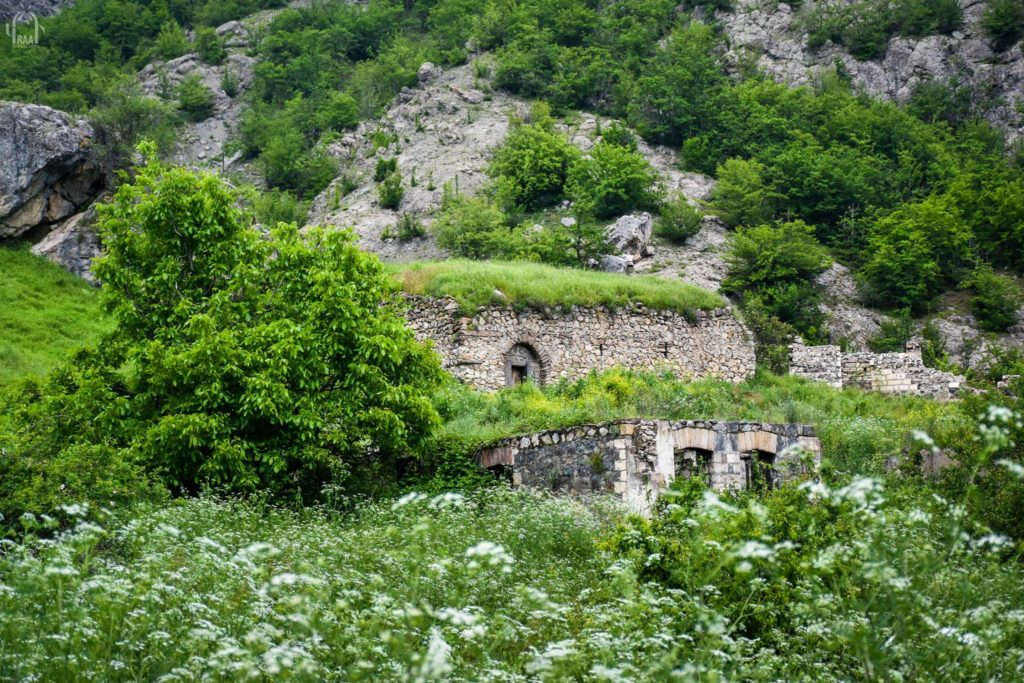
Location The St. Astvatsin Church is located in the village of Kyuratagh in the Republic of Artsakh’s Hadrut region. The village is currently occupied by Azerbaijan. Historical overview There is no historical information available about the church. While describing the village, Barkhudaryan mentions the church (Barkhutaryants 1895, 72-73). Architectural-compositional examination The architectural plan of St. Astvatsatsin’s church is rectangular (Fig. 1). On the inside, it is a vaulted hall. The church is made of rough and polished stones (Fig. 2). The only entrance is from the south. The rich decorative ornamental patterns capture the eye (Fig. 3). The church was built in 1683, according to the inscription on the lintel (the inscription is engraved in a left-right direction from the cross in the central section of the lintel) (Fig. 4). The following inscription is engraved on the left side of the cross sculpture: “This church was built in the year 1683 during the reign of Suleiman and Catholicos Jeremiah.”

Location The Church of the Holy Virgin is located in Jraghatsner village of Askeran region of the Artsakh Republic. The village is now occupied by Azerbaijan. Historical Overview There is no historical information about the Church. Makar Barkhudariants, describing the village, mentions the newly built Church of the Holy Virgin in the village (Barkhudariants 1895, 95). Architectural-Compositional Description The Church of the Holy Virgin is located in the center of the village (fig. 1). It is a single-nave vaulted hall, the vault is slender and bi-centered in the section (fig. 2). The church has a high altar, an almost rectangular apse and two sacristies; the inner walls are plastered (fig. 3). The Church of the Holy Virgin is built of rough stones, only the cornerstones, the stones of the entrances and windows are polished. In terms of its architectural style, the church is close to the urban architecture of Shushi; the builders were probably from Shushi. The church has two entrances, one from the west and one from the south. There are three large windows on the south façade (fig. 4). The construction inscription is engraved on the western entrance door (In memory of this Church of the H[oly] Virgin, /which was built in the village of Jraghatsner in 1882/ at the expense of the whole society of believers (fig. 5). The State Before and After the War During the Soviet years, the church was turned into a warehouse, and an annex was added on its western side. The church has been renovated. It was not destroyed after the 2020 war and the occupation of the village, but there is a video where the Azerbaijani militaries are saying a Muslim prayer right inside the church. For more details see https://monumentwatch.org/hy/alerts/%d5%a1%d5%a4%d6%80%d5%a2%d5%a5%d5%bb%d5%a1%d5%b6%d5%ab- %d5%a6%d5%ab%d5%b6%d5%be%d5%b8%d6%80%d5%a1%d5%af%d5%a1%d5%b6%d5 %b6%d5%a5%d6%80%d5%a8- %d5%b4%d5%a1%d5%b0%d5%b4%d5%a5%d5%a4%d5%a1%d5%af%d5%a1%d5%b6/.
Location Yeghtsi village is located in Nor Shahumyan (Karvachar) region of Artsakh, in the valley located in the middle of the gorge on left side of the middle stream of the Trtu River, at an average altitude of 1620 above sea level, in the central part of the rural area (Fig. 1). Historical overview There are no available historical data on the village, its historical name is not known, too. The toponym was named Yeghtsi after the re-liberation of Karvachar. Apparently, the Kurds who settled in the village at the end of the 19th century, based on the existence of a preserved standing church, named the village Kilisa. Judging by the architectural and construction solutions of the church, it was probably built at the beginning of the 17th century. Architectural-compositional description The church was built of local rough stones and lime mortar (Fig. 2). It is a single-nave basilica with a vaulted roof (external dimensions: 14.15×7.80 m). The semi-circular vault is supported by two pairs of pillars and an arcature (Fig. 3). The semicircular altar on the eastern side has vestries from the north and south (Fig. 4). Inside, the baptismal font is placed in the northern wall. The vestries have a rectangular plan and lack any windows. The illumination of the church hall was provided through four small windows opening from the east, south and west. The only entrance is from the south (Fig. 5). The most emphasized part of the church is the portal, for whose frame three khachkars belonging to the 11th (left) and 13th (upper and right) centuries have been used (Fig. 6). The two side khachkars bear inscriptions. On the pedestal of the left side khachkar we read: “I, axman Hasan, erected this holy sign as an intercessor to me and my departed” (Karapetyan 2019, 382). At the bottom of the other khachkar is the dated inscription, where we read: “In the year of 1246 of Armenians, I – smith Grigor, erected this cross for me and my spouse” (Karapetyan, 2019, 380). Holistic and fragmented khachkars were used on the upper parts and sides of the windows. There used to be a cemetery around the church, of which almost nothing has been preserved, except for one gravestone in the southern courtyard. Fragments of other gravestones and khachkars are visible in the walls of village houses built in the second half of the 20th century and in their vicinities. Dozens of engraved crosses have been preserved on a rock mass about 20 m north of the church (Karapetyan 2019, 380-384). The northern wall of the church is covered with soil and merged with the slant slope. The western part of the roof is partially destroyed.
Location The Grigor Narekatsi Church (fig. 1) is located on a hill about one km to the west of Drakhtik village, Hadrut region. The name Narekavank is more common among the locals. Drakhtik has been under Azerbaijani occupation since October 2020. Historical Overview The Drakhtik village is located 24 kilometers away from the city of Hadrut. M․ Barkhudariants mentions about the village: “The inhabitants are natives” (Barkhudariants 1895, 58). Architectural-Compositional Examination It is a single-nave hall with a rectangular plan. It is 13 meters long, 8 meters wide, 4 meters high. The building ends inside with a semicircular apse. The cupola rests on arches rising from three pairs of wall columns. It has a two sloped roof in outside. The only entrance opens from the west. The light comes from the windows that are opened in the west and the east walls. The western facade is decorated with four khachkars (fig. 2, 3), a phenomenon that is especially typical of the church building of the 17th-18th centuries. Inside the church there are several small khachkars fixed to the walls, there are also khachkar sculptures on the columns and arches (fig. 4, 5). The date of construction of the church: ՌՂԴ։(1645) is preserved on one of the hewn stones surrounding the entrance (fig. 6) and on the north central wall column inside the church (fig. 7). An old cemetery is surrounding the church. The State of the Church Before, During and After the War During the first Artsakh war, the eastern wall of the church and a part of the cupola were damaged by enemy shelling (fig. 8). The church has not suffered from the military operations of 2020, there is no information about the post-war state.

Location The Church of the Holy Virgin is located in the center of the village of Aknaghbyur (previously Gharabulagh) of the region of Askeran in the Artsakh Republic. The village in now under Azerbaijani occupation. Historical Overview There is no historical information about the church. Describing Gharabulagh, Makar Barkhudariants notes: “The Church of the Holy Virgin, made from limestone, is in danger…” (Barkhudariants 1895, 95). In his voluminous work Shahen Mkrtchian only mentions this church (Mkrtchian 1985, 207). Architectural-Compositional Description The church is a three-nave building with a rectangular plan. It has a wooden ceiling, a little part of which has been preserved, that rested on stone wall columns and the central wooden column, just like the churches of the 19th century of the Ararat Valley. Taking into consideration this circumstance and the architectural solution of the southern entrance, one can suppose that the church was built at the end of the 18th century or the beginning of the 19th century. It is built with the local white limestone (fig. 1). The walls are built with hewn and semi-hewn big and small stones. The entrances and their lintels, the corners of the church, as well as small windows are also made from hewn stones. The church had two entrances at the west and the south. Later the western one was closed and transformed into a window. On the eastern side the church has three windows (fig. 2). The old cemetery of the village is surrounding the church (fig. 3, 4), with its grave-stones of mainly 18th-20th centuries (Ghahramanian 2015, 30). The State of the Church before and after the War The church was not damaged during the Artsakh war. Before the war of 2020 it was already in a badly wrecked state. The walls have great fissures and crumbled parts. During the Soviet years the partly damaged church was reconstructed and used for practical needs. The western entrance was closed and transformed into a big window, while the demolished cupola was replaced by a roof which rests in the center on wooden columns, simply erected on the pavement (fig. 5). After the war of 2020 and the occupation of the village, there is no information about the church.

Location The archaeological site of Gyavurkala (literally, “Fortress of the Unbelievers”) is located east of Nor Haykajur village in Martakert region of the Artsakh Republic (Sofulu in Aghdam region in Soviet times). Gyavurkala settlement was partially studied by Azerbaijani archaeologists in the 50-70s of the last century, who emphasized the Christian affiliation of the settlement (Vahidov 1965, 167-183). The ruins of an unearthed early medieval church (they were covered again with soil after the end of the Soviet period excavations), the necropolis with sarcophagi, and the pillar of an early medieval cruciform obelisk can still be seen here (Fig. 1). Historical overview There is no available data from historical sources on the settlement and the church. Architectural-compositional examination In 2013, the Artsakh Tigranakert expedition team (H. Petrosyan, N. Yeranyan, L. Kirakosyan, L. Minasyan) carried out excavations of the ancient church of the archaeological site. These excavations provided an opportunity to make preliminary observations about the Gyavurkala settlement and the single-nave church located there (Fig. 2). The settlement stretches over a hill, which is 6.0 m elevated from the surrounding plain. The upper flat surface is 160.0 m long from east to west and 120.0 m from north to south orientation, occupying an area of about 2.0 ha. Preliminary observations bring to light the remains of a group of architectural complexes. The ruins of an early medieval church can be observed in the southern part of the settlement․ South and south-east of the hill, about 100 m from the center, there is a necropolis with early Christian slabs and sarcophagi (Fig. 3). Fragments of early medieval architectural details – cross-shaped ornaments, column bases, obelisks, their pedestals and other fragments can be found everywhere.

Location The historic Aghbatkhert settlement and church are located in the upper valley of the Aghavno River, about 3 km south of Hak village in the Kashatagh region of the Artsakh Republic (Fig. 1), at an altitude of 1550 meters above sea level. After 44-day war, it is under the control of Azerbaijan. Historical overview We can meet the first mention of the name of the monument in Stepanos Orbelyan’s “History of the Province of Syunik”, where it is mentioned as Aghakhird or Aghakherd in the list of tax-paying villages of Tatev. However, according to Aleksan Hakobyan, there is a mistake, due to which Aghbatrekht – the last village of Aghahetchk canton, was mentioned as the first village of Haband canton followed by Aghahetchk (Hakobyan 1982, 276). No other historical data is available about the monument. Architectural-compositional examination The church of Aghbatkhert does not have the volumetric solutions typical of a spiritual structure. It consists of two adjacent rooms built of local raw stone and lime mortar, whose entrances are opened from the southern side. The structure with 150 cm thick walls is surrounded by ramparts (Fig. 2). The fact that they are churches is evidenced by the nine-line inscription on the southern wall of the eastern room (Fig. 3), where the rooms are called Mother of God and St. Gregory: “By the will of God, I – priest Manvel, afterwards renewed the [rooms] of Our Lady of God and St. Gregory, in memory of my soul, my father – priest Kirakos, my mother Mina, my brothers – friar Tiratzu, Tateos. Remember [us] in Christ, and God will remember you. Servant Vardan – the priest of the church. Remember in [your] prayers: in the year of 1419. Remember Tatos in [your] prayers” (Hakobyan 2009, 230).
Location St. Mariam Astvatsatsin Church (Figs. 1, 2) is located on a hillside in the northwestern part of Arakel village in Hadrut region. It is presently under the occupation of Azerbaijan.

Location St. Hripsime Church is located in the center of Vardashat village of Hadrut region (Fig. 1). Historical overview Vardashat village is located 3 km west of Hadrut town. In historical literature it is referred to as Vordnashat. Speaking about the village, M. Barkhudaryan mentions: “The residents of Vordnashat have moved from Mil town, the land is fragile and less productive…” (Barkhutarian 1895, 46). In the Soviet period the name Edisha was used, in the post-Soviet period it was officially named Vardashat. Since October 2020 Vardashat has been under Azerbaijani occupation. Architectural-compositional examination It is a single-nave hall with a rectangular plan. It has a semicircular altar with two vestries. The bema is currently destroyed. It is built of local gray limestone. It is vaulted internally, has a gabled roof outwardly, which used to be covered with asbestos sheet during the Soviet years. It has three windows on the eastern, western and southern sides. The entrance, surrounded by hewn stones, opens from the south (Fig. 2). The year 1896, which is probably not the year of the construction of the church, but rather the year of its reconstruction, has been preserved on the lintel with decorative ornaments, since the year of 1695 has been preserved on the sundial on the southern wall (Fig. 3). We read on the inscribed stone embedded in the southern wall: “This is the name of the church” (Fig. 4). A tombstone with a simple cross is placed on the immediate threshold of the entrance (Fig. 5). To the north of the church, the old cemetery is preserved with standing tombstones. The church was used for economic purposes during the Soviet years.
Location The church is located in the centre of Madatashen village. Historical overview According to M. Barkhutaryants, it is a monument “newly built, of stones cemented with lime mortar” that was constructed at the end of the 19th century (Barkhutaryants 1895, 70). Architectural-compositional description It is a single-nave hall with a half-circular altar and adjacent vestries. It is built of local white limestone and lime mortar. The arch walls, windowsills and corners of the building are made of hewn limestone (Figs. 1-3). The dimensions of the monument are 16.7 meters long and 9.5 meters wide. The roof is collapsed (Fig. 4). The only entrance opens from the west, has 3 windows on the southern and eastern sides, and 1 window on the western side.
Location The church is located in Karmrakutch village, at an elevated point (Fig. 1). Historical overview Although Makar Barkhutaryants brings references on the church, the year of construction is missing. The dates of construction (1844) and renovation (1964) are engraved on the arch lock stone of the entrance facade (Fig. 2). Architectural-compositional description The church is a single-nave hall with a semi-cylindrical vault, an eastern semicircular altar and adjacent vestries. It is built of rough limestone and lime mortar. The cornerstones, windows and door sills are hewn. The dimensions of the monument are 12.8 m long and 7.4 m wide (Barkhutaryants 1895, 70). The only entrance is from the southern side. The hall is illuminated through narrow windows from the eastern altar and the western facade and the opening of the belfry crowned with a six-column rotunda in the center of the vault (Fig. 3). The church was restored in the 2000s and covered with tiles.

Location The church is located in Khandzadzor village of Hadrut region of the Artsakh Republic. The village is situated on the southeastern slope of Dizapayt, in a bare and unattractive area (Fig. 1), from where it got its name. The village is also called Tsarishen, which is associated with a large elm growing in the center of the village (Mkrtchyan 1985, 128). Researcher Shahen Mkrtchyan gives a very brief description of the village and the church in his book on the monuments of Nagorno Karabakh, published in Armenian in 1985. The author refers to the church in more detail in the book dedicated to the monuments of Nagorno Karabakh, already published in Russian in 1988 (Мкртчян 1988, 104). The church is located in the southeastern, elevated district of the village, next to the monument dedicated to the Patriotic War. Historical overview There is no historical information about the church. According to the certificate of St. Astvatsatsin Church of Khandzadzor made by the Monument Protection Department of the MESCS of the Artsakh Republic, the church was built in the 19th century on the site of a former church. Architectural-compositional description The church plan presents a rectangular, single-nave vaulted hall with an eastern semicircular altar and adjacent vestries (Fig. 2), at that the bema is only one step above the prayer hall (Fig. 7). The cylindrical vault rests on an arcade composed of wall-adjacent columns. The dimensions of the church are 14 X 6 X 7 meters. The only entrance is from the south (Fig. 3). There are two large cross reliefs on the upper stone of the lintel, which was reused twice and adapted for the lintel. On the right and left sides of the entrance there are khachkars typical of the 17th century (Fig. 4), whose right side has an inscription. The church is built of local semi-finished limestone (Figs. 5, 6). The condition before and after the war The church was not damaged during the Artsakh wars, it served as a warehouse during the Soviet years. It needed to undergo repairs. It is located in Hadrut region presently occupied by Azerbaijan and there is no information about its future.
Location The church is located about 600 meters east of Berdahonj fortress, on an elevated place in a forested area, on the edge of the old road leading to Shekher. Historical overview Makar Barkhutaryants mentions this church, but does not provide any information about the construction period (Barkhutaryants 1895, 90).

Location Berkni village, which is part of Kovsakan (Zangelan) settlement, is located in Kashatagh region of the Artsakh Republic, 110 km south of Berdzor, 1 km away from the RA border. There is a single-nave basilica-type church 0.9 km away from the village on the left side of the Tsav River (Figs. 1, 2). Historical overview There exist no bibliographic data and records about the church. Based on architectural-compositional solutions and the stylistics of the existing cross images, the church dates back to the 17th century. Architectural-compositional examination The church of Berkni is built of local rough stone and lime mortar. It used to be plastered inwardly. The structure is a single-nave, vaulted basilica with an accentuated arched altar and a pair of rectangular vestries on the eastern side, with the external dimensions of 14.50×9.10 meters (Karapetyan 2001, 196, Fig. 3). The semi-cylindrical vault rests on double-span arches adjacent to the walls and is fixed by an arch rising on the pilasters attached to the northern and southern walls (Fig. 4). The only entrance is from the southern side. The church has five windows, three of which open on the eastern wall (one on the high altar and two on the segments of vestries), one on the southern wall and one on the western wall. There are window-niches on the right and left sides of the altar. The baptismal font is located in the niche of the northern wall. Khachkars are embedded into the walls (Fig. 5). The cemetery of the settlement is located near the building. There are simple tombstones here, some of which bear cross reliefs. Remains of a small structure can be observed in the centre of the cemetery (Rkoyan 2015). One of the khachkars is dated to the 11th century (Fig. 6). The condition before, during and after the war The church of Berkni was not subjected to changes before or after the war. Bibliographic examination Researcher S. Karapetyan in his book “Armenian cultural monuments in the region of Karabakh” describes the village and the church but does not mention the cemetery (Karapetyan 2001, 195).
Location The church is located in the center of Ukhtadzor village in Hadrut region of the Artsakh Republic, in a densely built-up residential area (Fig. 1). At real time it is under the Azerbaijani occupation. Historical overview The data about the church are scarce. According to the building inscription, it was built in 1692. Architectural-compositional description The monument is a single-nave vaulted hall with an eastern semicircular altar and attached vestries. It is built of rough limestone and lime mortar (Figs. 2, 3). The roof is covered with soil. It is completely stuck in the ground from the north (Fig. 4). The entrance is from the south, the curbs and the lintel are hewn, decorated with cross compositions (Fig. 5). The slabs with engraved crosses and fragments of khachkars are embedded into the walls (Fig. 6).

Location St. Astvatsatsin Church is located on the elevated northern edge of Sarinshen village of Hadrut region of Artsakh (Fig. 1). Historical overview Sarinshen village was originally called Shaghakh, which took its name from the famous Shagakh or Shakhkakh monastic complex near the village. The data on Sarinshen village and St. Astvatsatsin Church that have reached us date back to the 19th century: “Shaghakh village – Sari Shen: It is founded on the mountain of Karaglukh village: the residents migrated from Gharadagh, the land is royal, the local harvest is the same (sheep, emmer wheat, spring wheat, flax, millet), excellent air, climate and water, 115 years long life, the church of Saint Astvatsatsin built of stones and lime mortar, the priest comes from Tsamdzor. Households – 70, males – 275, females – 230” (Barkhutaryants 1895, 64). According to the inscription carved on the stone with a cross relief, embedded in the mid-part of the northern vestry and the altar of St. Astvatsatsin Church, it was built in 1867, but the khachkars and reliefs of the 16th-17th centuries on the walls prove that the church was built on the site of an older sanctuary. Architectural-compositional description St. Astvatsatsin Church is a vaulted building with a single-nave hall (dimensions: 15․1×6․3 meters, height: 7 meters). It is built of local rough and unfinished stones (Fig. 2). The cornerstones of windows, pilasters, arcature, niches and the bema are polished. The building inwardly ends in the east with a semicircular altar and adjacent rectangular vestries (Fig. 3). The vault rests on arrow-shaped arches rising from two pairs of pilasters. On the northern wall, in the niche, adjacent to the entrance of the vestry, there is a baptismal font, on both sides and above of which there are three small khachkars dated the 17th century (Fig. 4). In the southern wall opposite the font there is another niche, which served as an aumbry. The only entrance is from the south, which was closed during the Soviet years (Fig. 5). In the wall parallel to the closed entrance on the southern facade, two rectangular hewn stones with a pair of cross reliefs taken in similar frames are embedded. The illumination was provided through 6 windows opened from the east, south and west. During the Soviet era, the small western window was widened, and a new entrance was opened in the direction of the second window of the southern wall and the church served for another purpose (club-library). On the inner walls of the church, especially in the niches, cross reliefs and small donative khachkars are abundantly embedded. Particularly noteworthy are the reliefs on the bema, which represent the Just Judgment in the person of the Three Patriarchs and the enlightened coming of the Archangel Gabriel armed with a sword and the Cross (Fig. 6). The gable roof of the church was originally made of stone, which was covered with asbestos (slate) sheet during the Soviet years (Fig. 7). In 2016-2017, the slabs of the church were restored, some reinforcement works were carried out (Fig. 8).

Location St. Stepanos Church is located in Pletants village of Hadrut region of Artsakh, on the northern edge, on the south-facing slope. Historical overview The information on Pletants and St. Stepanos Church (Fig. 1) that have reached us dates back to the 19th century. Makar Barkhudaryants writes the following about the village and the church: “Pletants (Plitan): it is founded on the slope of a gorge of the same mountain (Arevasar): the people are indigenous, the land is royal, it has also a garden, pupae and an orchard, harmless air, climate and water: St. Stepanos Church, made of stone and lime mortar, the priest comes from Hatrut. 20 households: 90 males, 70 females” (Barkhutaryants 1895, 70). According to the building inscription engraved on the entrance lintel, the church was built in 1651. No other details are known about the construction of the church. Architectural-compositional description St. Stepanos Church is a vaulted building with a three-nave hall (dimensions: 17.2×8.7 meters). It is built of local rough-hewn stones (Fig. 2). The cornerstones of the entrance, windows, pillars, columns and arcature are polished (Fig. 3). Large-sized semi-finished limestone was used in the lower masonry of the walls. The walls are fixed with lime mortar. The hall is divided into naves by means of a pair of arches (Fig. 5). The baptismal font, crowned with an arrow-shaped arch, is placed in the niche adjacent to the entrance of the northern vestry. The building internally ends in the east with a semicircular altar and adjacent rectangular vestries (Fig. 4). There are niches of different sizes on the walls of the altar and vestries. The building is externally covered with a gable roof. The only entrance is opened from the centre of the southern front to the section deviated to the west. The entrance has a beautifully designed arched frame, the date of construction is engraved on the lintel (Fig. 6). The illumination was done through three small windows from the east, one from the west and two from the south. The window opening from the western facade externally has a cruciform frame (Fig. 7). The northern wall is externally merged with a slant slope and is covered with earth. A rectangular gravestone dated 1854 is located to the south of the church, to the east of the entrance, and two 17th century khachkars with simple cross images.
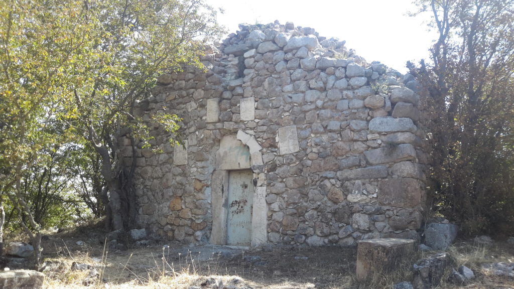
Location The Church of the Holy Resurrection (figs. 1, 2) is located in the Hadrut region, in the village of Hin Kochbek on the south-eastern slope of Mount Arevasar.

Location St. Astvatsatsin Church (Figs. 1, 2) is located in the center of Jraberd (Mulkudara) village of Hadrut region. Historical overview Mulkudara village (Fig. 3) is located 11-12 km southwest of the city of Hadrut. The village was evacuated of Armenians in 1991 as a result of Operation Ring. It was liberated in 1993 and renamed Jraberd. Only a few families returned to the village, who left the settlement in the following years. Jraberd has been under Azerbaijani occupation since October 2020. Architectural-compositional examination St. Astvatsatsin Church is a 19th century structure by its composition. It is a rectangular single-nave hall. The barrel vault rests on longitudinal and transverse arches rising from the columns attached to the walls (Fig. 4). The roof is gable, covered with soil. It is built of local white limestone. The only entrance opens from the south. A fragment of a gravestone of the 16th-17th centuries, decorated with cross-shaped compositions, has been preserved in the southern wall (Fig. 5). During the Soviet years, the church was used as a village club.

Location The church is located in Tzor village of Hadrut region of the Artsakh Republic (Mkrtchyan 1985, 132). The village is located at the southern foot of the historic Tzoraberd fortress (Barkhutaryants 1895, 43). Historical overview There is no historical data about the church. Its brief description is given by Makar Barkhudaryants: “…Amenaprkich Church, built on four pillars, marvelous and beautiful, its people-facing facade of the bema is delicately decorated, the length is 22 m, the width is 12 m 35 cm, externally on the front stone of the door: “In memory of the year of 400… a priest…” (Barkhutaryants 1895, 43). Architectural-compositional description St. Amenaprkich Church of Tzor is located in the central part of the village (Fig. 1). The building is a three-nave basilica with four pillars, a semicircular high altar and adjacent vestries (Fig. 2). It is built of local rough stone, has small windows. The only entrance to the church is from the south (Fig. 3). One line of illegible inscription has been preserved on the lintel (cf. CAE 1982, 186). Based on the compositional, architectural solutions of the church, it dates back to the 18th-19th centuries (Mkrtchyan 1985, 132). Internally the church is vaulted (Fig. 4), its only decoration is the rich sculptured area under the bema (Fig. 5), where the name Giriqor is read from top to bottom (CAE 1982, 187). The condition before and after the war During the Soviet years, the church area was used for economic purposes, some windows were widened (Fig. 6). In 2016-2020, the church was renovated by benefactors of Tsor origin (https://www.youtube.com/watch?v=7TeU08kxzFU, https://www.youtube.com/watch?v=YmTojWJU9Ns). The church was not damaged during the Artsakh wars, it is now located in the Hadrut region occupied by Azerbaijan and there is no information about its further destiny.


